Home » Information and Communications Technology » Technology & Media » Denmark Geospatial Analytics Market

Denmark Geospatial Analytics Market

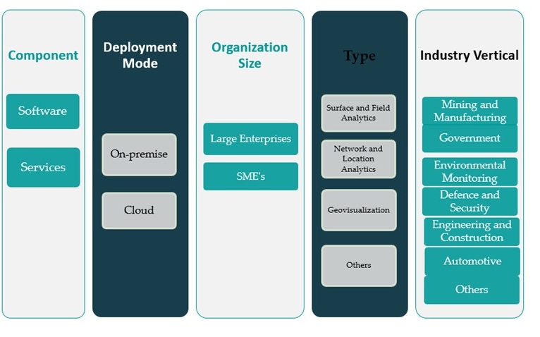
Denmark Geospatial Analytics Market By Component (Software, Services); By Deployment Mode (On-premise, Cloud); By Organization Size (Large Enterprises, SMEs); By Type (Surface and Field Analytics, Network and Location Analytics, Geovisualization, Others); By Industry Vertical (Mining and Manufacturing, Government, Environmental Monitoring, Defence and Security, Engineering and Construction, Automotive, Others) – Growth, Share, Opportunities & Competitive Analysis, 2024 – 2032

Price: $2699

Published: | Report ID: 93379 | Report Format : Excel, PDF
REPORT ATTRIBUTE DETAILS
Historical Period 2020-2023
Base Year 2024
Forecast Period 2025-2032
Denmark Geospatial Analytics Market Size 2024 USD 352.03 million
Denmark Geospatial Analytics Market, CAGR 6.5%
Denmark Geospatial Analytics Market Size 2032 USD 619.42 million

Market Overview:

Denmark Geospatial Analytics Market size was valued at USD 352.03 million in 2023 and is anticipated to reach USD 619.42 million by 2032, at a CAGR of 6.5% during the forecast period (2023-2032).

Several factors are propelling the adoption of geospatial analytics in Denmark. The integration of artificial intelligence (AI) and machine learning (ML) with geographic information systems (GIS) enhances the capabilities of geospatial tools, enabling more accurate and efficient spatial data analysis. This technological synergy supports applications in climate monitoring, urban planning, and disaster management. Additionally, Denmark’s focus on smart city initiatives and sustainable development drives the demand for advanced geospatial solutions to optimize resource allocation and infrastructure development. Government-backed programs encouraging digital innovation further boost the implementation of location-based technologies. Moreover, private sector interest in real-time analytics for logistics, energy, and agriculture strengthens the market’s upward trajectory.

Within Europe, Denmark stands out for its proactive approach to adopting geospatial technologies. The country’s emphasis on digitalization and environmental sustainability aligns with the broader European trend of integrating geospatial analytics into various sectors, including transportation, energy, and public services. Denmark’s strategic investments in smart infrastructure and its commitment to leveraging data-driven insights position it as a key player in the regional geospatial analytics landscape. Urban centers like Copenhagen and Aarhus are particularly active in using geospatial tools to manage traffic flows, reduce emissions, and enhance livability. Additionally, collaborations between research institutions and public agencies continue to support innovation and knowledge sharing across regions.

Design Element 2

Access crucial information at unmatched prices!

Request your sample report today & start making informed decisions powered by Credence Research!

Download Sample

CTA Design Element 3

Market Insights:

  • The Denmark Geospatial Analytics Market was valued at USD 352.03 million in 2023 and is projected to reach USD 619.42 million by 2032, growing at a CAGR of 6.5%.
  • The integration of AI and ML with GIS is enhancing spatial data processing capabilities, enabling more accurate decision-making in urban planning, disaster response, and climate monitoring.
  • Government-led digital transformation initiatives and public sector innovation are laying a strong foundation for widespread geospatial technology adoption across Denmark.
  • Urban centers like Copenhagen and Aarhus are leading smart city advancements by implementing geospatial tools to improve mobility, emissions control, and livability.
  • Environmental agencies and private firms are leveraging geospatial analytics for climate resilience, ecosystem monitoring, and regulatory compliance in sustainability projects.
  • Major challenges include data privacy regulations under GDPR, high implementation costs for SMEs, and a shortage of skilled geospatial professionals in the domestic workforce.
  • Regionally, the Capital Region dominates market share, followed by Central and Southern Denmark, with each region adopting geospatial tools in line with local infrastructure and economic priorities.

Report Scope

This report segments the Denmark Geospatial Analytics Market as follow

Denmark Geospatial Analytics Market

Market Drivers:

Government Initiatives and Digital Transformation

The Danish government plays a central role in driving the growth of the geospatial analytics market through robust digitalization strategies and public sector innovation. As part of its Smart Nation and Digital Strategy agendas, Denmark has integrated geospatial tools into numerous administrative and planning functions. These initiatives promote the use of spatial data in areas such as land management, public transportation planning, emergency response coordination, and infrastructure development. For example, the Danish Geodata Agency manages more than 520,000 km of cadastral boundaries, providing essential geospatial data for property management, land transactions, and public administration. By fostering an environment where spatial intelligence is embedded in public services, the government sets the foundation for wide-scale geospatial analytics adoption. In addition to policy support, public funding and regulatory frameworks have facilitated collaboration between government bodies and technology firms. Programs designed to enhance transparency, improve citizen services, and optimize resource utilization increasingly depend on real-time geospatial data. As public institutions expand their reliance on digital platforms, the demand for comprehensive geospatial analytics continues to rise, further solidifying the sector’s long-term relevance.

Integration of Advanced Technologies

Technological advancements are a significant force behind the accelerating adoption of geospatial analytics in Denmark. The integration of artificial intelligence (AI), machine learning (ML), and big data analytics with geographic information systems (GIS) has expanded the scope and utility of geospatial tools. For instance, the Geological Survey of Denmark and Greenland (GEUS) utilizes GIS and remote sensing technologies to enhance the accuracy and accessibility of geological and environmental data, supporting sectors such as water management and energy production. These integrations allow stakeholders to extract predictive insights, automate pattern recognition, and visualize complex data in user-friendly formats. Enhanced processing capabilities enable organizations to derive more value from spatial datasets, improving decision-making across industries. Cloud computing has also revolutionized data accessibility, enabling real-time analytics and cross-platform integration. As a digitally advanced nation, Denmark benefits from a high level of internet penetration and IT infrastructure, which supports the seamless deployment of geospatial platforms. This technological maturity allows for the rapid implementation of solutions in diverse fields such as urban planning, agriculture, and logistics, reinforcing the country’s leadership in data-driven governance and innovation.

Rising Demand for Smart City Solutions

The development of smart cities across Denmark is another key driver fueling the geospatial analytics market. Urban regions like Copenhagen and Aarhus are leveraging location-based technologies to enhance livability, sustainability, and operational efficiency. Geospatial data supports applications such as intelligent traffic systems, renewable energy optimization, air quality monitoring, and waste management. These use cases demonstrate the critical role of geospatial analytics in building resilient and efficient urban ecosystems. Smart city projects often rely on interconnected digital infrastructures that integrate real-time sensor data, satellite imagery, and location intelligence. As municipalities invest in digital twins and other urban simulation tools, geospatial analytics becomes essential for modeling scenarios, identifying vulnerabilities, and streamlining resource allocation. This shift towards smart governance is creating sustained demand for advanced geospatial solutions across local government bodies and infrastructure operators.

Environmental Monitoring and Climate Resilience

Denmark’s strong commitment to environmental sustainability is closely linked with the growing use of geospatial analytics in climate monitoring and resilience planning. The country faces various environmental challenges such as coastal erosion, rising sea levels, and changes in agricultural productivity due to shifting climate patterns. Geospatial tools provide critical insights into these issues by enabling precise tracking of environmental variables over time. They support decision-making in areas such as land use planning, disaster risk reduction, and biodiversity conservation. National and regional agencies increasingly rely on satellite data and remote sensing to monitor changes in ecosystems and natural resources. These insights allow authorities to implement more targeted and efficient environmental policies. Additionally, the private sector is adopting geospatial analytics to meet sustainability goals, conduct environmental impact assessments, and manage compliance. As climate resilience becomes a strategic priority, the integration of geospatial technologies across sectors is expected to accelerate.

Market Trends:

Adoption of Real-Time Geospatial Intelligence

A prominent trend shaping the Denmark geospatial analytics market is the increasing demand for real-time data processing and dynamic spatial intelligence. Organizations across sectors are seeking solutions that offer immediate insights derived from streaming data sources such as sensors, satellites, mobile devices, and drones. This trend is particularly evident in industries like logistics, maritime operations, and utilities, where time-sensitive decision-making is critical. Real-time geospatial analytics enhances situational awareness, enabling faster response times and improved operational efficiency. The adoption of Internet of Things (IoT) networks and edge computing technologies has further empowered Danish companies to leverage real-time geospatial capabilities at scale.

Growth of Location-Based Services in Retail and Finance

Another significant trend is the growing utilization of location-based services (LBS) in consumer-facing industries such as retail, finance, and telecommunications. Businesses are using geospatial analytics to understand customer movement patterns, personalize marketing campaigns, and optimize store placements. In Denmark’s highly digitized economy, mobile penetration and digital payment usage provide rich geolocation datasets, allowing enterprises to deliver tailored experiences and improve customer engagement. For instance, companies using platforms like CARTO have reported that integrating spatial data has enabled them to geo-enable their datasets, multiply their analytical reach, and support strategic decision-making for investment and risk assessment. In the financial sector, geospatial tools are being employed to assess regional credit risks, detect fraud, and enhance branch network optimization strategies, demonstrating the expanding role of spatial intelligence beyond traditional applications.

Advancement of 3D and Digital Twin Technologies

The increasing adoption of 3D mapping and digital twin technologies represents a transformative trend in Denmark’s geospatial landscape. Municipalities and infrastructure firms are investing in 3D geospatial platforms to create accurate models of buildings, transport systems, and public utilities. These models support simulation, forecasting, and infrastructure management, especially in urban development and smart city planning. For example, Energinet, Denmark’s national transmission system operator, contracted Fugro to capture aerial lidar and imagery data across 3,000 km of power lines. The resulting 3D digital twin, developed using Fugro’s Roames® technology, simulates the network to monitor critical clearances, analyze vegetation growth, and support predictive maintenance planning. In Denmark, digital twin implementations are aiding authorities in visualizing complex urban systems, monitoring construction progress, and identifying structural inefficiencies. This trend is expected to gain momentum as cities pursue sustainability and resilience through digital transformation initiatives, with 3D GIS emerging as a core enabler of such efforts.

Collaborative Ecosystems and Open Data Integration

Denmark’s emphasis on collaboration and open data sharing continues to shape the evolution of the geospatial analytics market. Public institutions, research organizations, and private enterprises are increasingly partnering to develop interoperable geospatial platforms. These collaborative ecosystems encourage innovation, reduce data silos, and improve decision-making through shared spatial intelligence. The availability of open-source geospatial data, facilitated by national programs and EU directives, is empowering developers and startups to create specialized applications tailored to local needs. As open data becomes more standardized and accessible, it is likely to spur new services and business models in the Danish geospatial ecosystem, reinforcing a trend toward inclusivity and innovation.

Market Challenges Analysis:

Data Privacy and Regulatory Compliance

One of the foremost restraints in the Denmark geospatial analytics market is the complexity of navigating data privacy regulations. For instance, as geospatial analytics often involves the collection and processing of sensitive location data, ensuring compliance with the General Data Protection Regulation (GDPR) poses a significant challenge for businesses and public agencies. Strict data governance policies limit the scope of data sharing and user tracking, which can hinder the development of real-time analytics and personalized location-based services. Companies must invest in robust data protection frameworks and anonymization techniques to maintain regulatory compliance, which may increase operational costs and delay project implementation.

High Implementation Costs and Technical Complexity

The initial investment required for deploying advanced geospatial analytics solutions remains a substantial barrier, particularly for small and medium-sized enterprises (SMEs) and local municipalities. The costs associated with high-resolution satellite imagery, LiDAR equipment, GIS software licenses, and skilled personnel can be prohibitive. Additionally, integrating geospatial systems with legacy IT infrastructure demands technical expertise and substantial customization, which can further complicate implementation. This financial and technical burden slows down the adoption rate, especially in sectors with limited digital maturity.

Limited Skilled Workforce and Training Gaps

Another challenge facing the Danish geospatial analytics market is the shortage of specialized talent. As the demand for professionals skilled in GIS, data science, and AI-integrated spatial analysis grows, the current workforce supply struggles to meet the rising expectations. Educational institutions and training programs are gradually addressing this gap, but in the short term, talent scarcity may limit innovation and slow the expansion of geospatial applications. Organizations must invest in internal training or collaborate with academic institutions to develop the necessary skill sets.

Market Opportunities:

The Denmark geospatial analytics market presents substantial opportunities as the country accelerates its digital transformation across public and private sectors. The increasing demand for data-driven decision-making in urban planning, infrastructure development, environmental management, and transportation systems provides fertile ground for geospatial solutions. With Denmark’s commitment to becoming a leader in sustainability and smart city innovation, there is a growing need for tools that offer spatial insights into energy usage, emission patterns, and urban mobility. Geospatial analytics providers can capitalize on these initiatives by offering customized platforms that support predictive modeling, real-time monitoring, and integrated digital twin environments. The government’s support for open data frameworks and public-private innovation partnerships further enhances market entry and expansion potential for technology firms.

Additionally, as sectors like agriculture, maritime logistics, and public health become increasingly reliant on spatial intelligence, the scope for geospatial applications is rapidly expanding. Denmark’s agricultural sector, for instance, can benefit from precision farming enabled by satellite data and IoT devices, while ports and logistics hubs can optimize operations using geospatial tools for route mapping and cargo tracking. The financial and retail industries are also beginning to explore location-based analytics to refine customer segmentation and regional market strategies. As cloud computing and AI become more accessible, even small and mid-sized organizations are expected to adopt spatial analytics solutions. This evolving landscape presents a significant opportunity for geospatial technology vendors, system integrators, and analytics service providers to deliver tailored, scalable solutions that address Denmark’s diverse and digitally driven market needs.

Market Segmentation Analysis:

The Denmark geospatial analytics market is segmented across several key dimensions, each reflecting distinct areas of application and adoption.

By component, the market is divided into software and services. Software solutions dominate the segment due to high demand for spatial analysis, mapping, and visualization tools. However, services—including consulting, system integration, and support—are gaining momentum as enterprises increasingly seek end-to-end geospatial implementations tailored to their unique operational needs.

By deployment mode, cloud-based solutions are witnessing rapid adoption, driven by Denmark’s robust digital infrastructure and growing preference for scalable, cost-efficient platforms. While on-premise deployment continues to serve organizations with high security requirements, the flexibility and real-time processing capabilities of cloud-based systems make them attractive for a wide range of users.

By organization size, large enterprises remain key adopters of geospatial analytics due to their greater resources and broader operational scope. However, small and medium-sized enterprises (SMEs) are increasingly investing in geospatial tools, particularly through cloud-based and subscription models that lower entry barriers.

By type, network and location analytics are leading due to their wide-ranging use in logistics, public services, and retail. Surface and field analytics are vital for environmental monitoring and agriculture, while geovisualization plays a critical role in urban planning and infrastructure projects.

By industry verticals, government and environmental monitoring lead in adoption, supported by national initiatives focused on smart governance and sustainability. Other significant verticals include defense and security, engineering and construction, and automotive—each leveraging geospatial analytics for efficiency, safety, and innovation.

Segmentation:

By Component:

  • Software
  • Services

By Deployment Mode:

  • On-premise
  • Cloud

By Organization size:

  • Large Enterprises
  • SME’s

By Type:

  • Surface and Field Analytics
  • Network and Location Analytics
  • Geovisualization
  • Others

By Industry Vertical:

  • Mining and Manufacturing
  • Government
  • Environmental Monitoring
  • Defence and Security
  • Engineering and Construction
  • Automotive
  • Others

Regional Analysis:

Denmark’s geospatial analytics market exhibits notable regional variations, influenced by factors such as urbanization, technological infrastructure, and sector-specific demands. The country is administratively divided into five regions: Capital Region (Hovedstaden), Central Denmark Region (Midtjylland), North Denmark Region (Nordjylland), Region Zealand (Sjælland), and Region of Southern Denmark (Syddanmark).

Capital Region (Hovedstaden)

The Capital Region, encompassing Copenhagen, holds the largest share of Denmark’s geospatial analytics market. This dominance is driven by the region’s advanced digital infrastructure, concentration of governmental agencies, and numerous smart city initiatives. Copenhagen’s commitment to sustainable urban development and intelligent transportation systems necessitates sophisticated geospatial solutions for efficient planning and management.

Central Denmark Region (Midtjylland)

Central Denmark Region ranks second in market share, supported by a robust industrial base and significant investments in renewable energy projects. The region’s focus on wind energy and sustainable agriculture leverages geospatial analytics for site selection, resource management, and environmental monitoring. Additionally, the presence of research institutions fosters innovation in geospatial technologies.

Region of Southern Denmark (Syddanmark)

The Region of Southern Denmark holds a substantial share of the market, attributed to its strategic location and emphasis on manufacturing and logistics. The region utilizes geospatial analytics to optimize supply chain operations, infrastructure development, and cross-border trade activities. Efforts to enhance digital connectivity further bolster the adoption of geospatial solutions.

Region Zealand (Sjælland)

Region Zealand’s market share is growing, driven by initiatives in environmental conservation and rural development. The region employs geospatial analytics for land use planning, water resource management, and biodiversity protection. Collaborations between local authorities and academic institutions contribute to the development of region-specific geospatial applications.

North Denmark Region (Nordjylland)

The North Denmark Region, while holding a smaller market share, is witnessing increased adoption of geospatial analytics in areas such as fisheries management and coastal monitoring. The region’s focus on marine ecosystems and climate resilience strategies underscores the importance of spatial data in policy-making and resource allocation.

Shape Your Report to Specific Countries or Regions & Enjoy 30% Off!

Key Player Analysis:

  • Cowi
  • Scanmatic AS
  • SAP SE
  • Google, Inc.
  • Bentley Systems, Incorporated
  • Alteryx, Inc.
  • Oracle Corporation
  • Hexagon AB
  • Surveys and Mapping Denmark
  • Trimble, Inc.
  • Esri
  • Microsoft Corporation

Competitive Analysis:

The Denmark geospatial analytics market is moderately competitive, characterized by the presence of both domestic players and global technology firms. Leading multinational companies such as Esri, Hexagon AB, and Trimble have established a strong foothold, offering advanced GIS platforms and spatial data solutions tailored to Danish infrastructure and urban planning needs. Local firms and startups contribute to the market with customized applications, especially in environmental monitoring, smart city planning, and agriculture. Public sector collaborations with research institutions further enhance innovation and knowledge transfer. The competitive landscape is driven by technological advancements, with players integrating AI, machine learning, and cloud-based analytics to deliver real-time insights. Additionally, the push for open data and sustainable solutions has encouraged companies to develop scalable, interoperable platforms. To remain competitive, firms are increasingly focusing on industry-specific solutions, strategic partnerships, and investments in user-friendly interfaces and mobile applications tailored to Denmark’s evolving digital ecosystem.

Recent Developments:

  • In March 2025, Esri announced a significant partnership with Google Maps Platform, integrating Google’s Photorealistic 3D Tiles into the ArcGIS suite. This collaboration enables users to create highly detailed and visually immersive 3D maps and scenes, supporting a wide range of applications such as urban planning, real estate, and public sector infrastructure projects.
  • In Oct 2024, Bentley Systems, Incorporated revealed a strategic partnership with Google to integrate Google’s high-quality geospatial content-including Photorealistic 3D Tiles-into Bentley’s infrastructure engineering software and digital twin platform. This partnership allows infrastructure professionals to design, build, and operate assets with improved geospatial context and actionable insights, leveraging Google’s geospatial data, AI, and cloud technologies.

Market Concentration & Characteristics:

The Denmark geospatial analytics market exhibits a moderate level of concentration, with a few dominant players holding significant market shares. Notably, global leaders such as Esri, Hexagon AB, and Trimble Inc. have established a strong presence, offering advanced GIS platforms and spatial data solutions tailored to Danish infrastructure and urban planning needs. These companies leverage their extensive R&D capabilities and comprehensive distribution networks to maintain a competitive edge. Additionally, local firms and startups contribute to the market by providing customized applications, especially in environmental monitoring, smart city planning, and agriculture. The market’s competitive landscape is further shaped by public sector collaborations with research institutions, enhancing innovation and knowledge transfer. The market is characterized by high innovation potential, driven by advancements in artificial intelligence (AI), machine learning (ML), and remote sensing technologies. These technological developments enable the integration of geospatial analytics into various sectors, including government, defense, transportation, and utilities. However, stringent regulations governing data privacy and security, such as the General Data Protection Regulation (GDPR), impact market growth by imposing compliance requirements on data collection and processing activities.

Report Coverage:

The research report offers an in-depth analysis based on Component, Deployment Mode, Organization size, Type and Industry Vertical. It details leading market players, providing an overview of their business, product offerings, investments, revenue streams, and key applications. Additionally, the report includes insights into the competitive environment, SWOT analysis, current market trends, as well as the primary drivers and constraints. Furthermore, it discusses various factors that have driven market expansion in recent years. The report also explores market dynamics, regulatory scenarios, and technological advancements that are shaping the industry. It assesses the impact of external factors and global economic changes on market growth. Lastly, it provides strategic recommendations for new entrants and established companies to navigate the complexities of the market.

Future Outlook:

  • Denmark is expected to witness increased integration of AI and machine learning in geospatial analytics for predictive insights.
  • Smart city initiatives will drive adoption of real-time spatial data platforms for urban planning and mobility solutions.
  • Environmental monitoring will remain a priority, with expanding use of geospatial tools in climate resilience and natural resource management.
  • Cloud-based geospatial solutions will dominate deployments due to scalability, cost-efficiency, and accessibility.
  • Public-private collaborations will enhance innovation, especially in digital twins and 3D visualization technologies.
  • SMEs will increasingly adopt geospatial analytics through subscription-based and open-source platforms.
  • The education sector is likely to strengthen training programs to address the shortage of skilled geospatial professionals.
  • The logistics and maritime sectors will utilize spatial data for route optimization and infrastructure planning.
  • Regulatory frameworks around data privacy will shape product development and platform compliance.
  • Cross-sector demand for real-time location intelligence will fuel continued market expansion across Denmark.

CHAPTER NO. 1 : INTRODUCTION 19

1.1.1. Report Description 19

Purpose of the Report 19

USP & Key Component 19

1.1.2. Key Benefits for Stakeholders 19

1.1.3. Target Audience 20

1.1.4. Report Scope 20

CHAPTER NO. 2 : EXECUTIVE SUMMARY 21

2.1. Geospatial Analytics Market Snapshot 21

2.1.1. Denmark Geospatial Analytics Market, 2018 – 2032 (USD Million) 22

CHAPTER NO. 3 : GEOPOLITICAL CRISIS IMPACT ANALYSIS 23

3.1. Russia-Ukraine and Israel-Palestine War Impacts 23

CHAPTER NO. 4 : GEOSPATIAL ANALYTICS MARKET – INDUSTRY ANALYSIS 24

4.1. Introduction 24

4.2. Market Drivers 25

4.2.1. Driving Factor 1 Analysis 25

4.2.2. Driving Factor 2 Analysis 26

4.3. Market Restraints 27

4.3.1. Restraining Factor Analysis 27

4.4. Market Opportunities 28

4.4.1. Market Opportunities Analysis 28

4.5. Porter’s Five Force analysis 29

4.6. Value Chain Analysis 30

4.7. Buying Criteria 31

CHAPTER NO. 5 : ANALYSIS COMPETITIVE LANDSCAPE 32

5.1. Company Market Share Analysis – 2023 32

5.1.1. Denmark Geospatial Analytics Market: Company Market Share, by Revenue, 2023 32

5.1.2. Denmark Geospatial Analytics Market: Top 6 Company Market Share, by Revenue, 2023 32

5.1.3. Denmark Geospatial Analytics Market: Top 3 Company Market Share, by Revenue, 2023 33

5.2. Denmark Geospatial Analytics Market Company Revenue Market Share, 2023 34

5.3. Company Assessment Metrics, 2023 35

5.3.1. Stars 35

5.3.2. Emerging Leaders 35

5.3.3. Pervasive Players 35

5.3.4. Participants 35

5.4. Start-ups /Code Assessment Metrics, 2023 35

5.4.1. Progressive Companies 35

5.4.2. Responsive Companies 35

5.4.3. Dynamic Companies 35

5.4.4. Starting Blocks 35

5.5. Strategic Developments 36

5.5.1. Acquisition & Mergers 36

New Product Launch 36

Regional Expansion 36

5.6. Key Players Product Matrix 37

CHAPTER NO. 6 : PESTEL & ADJACENT MARKET ANALYSIS 38

6.1. PESTEL 38

6.1.1. Political Factors 38

6.1.2. Economic Factors 38

6.1.3. Social Factors 38

6.1.4. Technological Factors 38

6.1.5. Environmental Factors 38

6.1.6. Legal Factors 38

6.2. Adjacent Market Analysis 38

CHAPTER NO. 7 : GEOSPATIAL ANALYTICS MARKET – BY COMPONENT SEGMENT ANALYSIS 39

7.1. Geospatial Analytics Market Overview, by Component Segment 39

7.1.1. Geospatial Analytics Market Revenue Share, By Component, 2023 & 2032 40

7.1.2. Geospatial Analytics Market Attractiveness Analysis, By Component 41

7.1.3. Incremental Revenue Growth Opportunities, by Component, 2024 – 2032 41

7.1.4. Geospatial Analytics Market Revenue, By Component, 2018, 2023, 2027 & 2032 42

7.2. Software 43

7.3. Services 44

CHAPTER NO. 8 : GEOSPATIAL ANALYTICS MARKET – BY DEPLOYMENT MODE SEGMENT ANALYSIS 45

8.1. Geospatial Analytics Market Overview, by Deployment Mode Segment 45

8.1.1. Geospatial Analytics Market Revenue Share, By Deployment Mode, 2023 & 2032 46

8.1.2. Geospatial Analytics Market Attractiveness Analysis, By Deployment Mode 47

8.1.3. Incremental Revenue Growth Opportunities, by Deployment Mode, 2024 – 2032 47

8.1.4. Geospatial Analytics Market Revenue, By Deployment Mode, 2018, 2023, 2027 & 2032 48

8.2. On-premise 49

8.3. Cloud 50

CHAPTER NO. 9 : GEOSPATIAL ANALYTICS MARKET – BY TYPE SEGMENT ANALYSIS 51

9.1. Geospatial Analytics Market Overview, by Type Segment 51

9.1.1. Geospatial Analytics Market Revenue Share, By Type, 2023 & 2032 52

9.1.2. Geospatial Analytics Market Attractiveness Analysis, By Type 53

9.1.3. Incremental Revenue Growth Opportunities, by Type, 2024 – 2032 53

9.1.4. Geospatial Analytics Market Revenue, By Type, 2018, 2023, 2027 & 2032 54

9.2. Surface and Field Analytics 55

9.3. Network and Location Analytics 56

9.4. Geovisualization 57

9.5. Others 58

CHAPTER NO. 10 : GEOSPATIAL ANALYTICS MARKET – BY INDUSTRY VERTICAL SEGMENT ANALYSIS 59

10.1. Geospatial Analytics Market Overview, by Industry Vertical Segment 59

10.1.1. Geospatial Analytics Market Revenue Share, By Industry Vertical, 2023 & 2032 60

10.1.2. Geospatial Analytics Market Attractiveness Analysis, By Industry Vertical 61

10.1.3. Incremental Revenue Growth Opportunities, by Industry Vertical, 2024 – 2032 61

10.1.4. Geospatial Analytics Market Revenue, By Industry Vertical, 2018, 2023, 2027 & 2032 62

10.2. Mining and Manufacturing 63

10.3. Government 64

10.4. Environmental Monitoring 65

10.5. Defence and Security 66

10.6. Engineering and Construction 67

10.7. Automotive 68

10.8. Others 69

CHAPTER NO. 11 : GEOSPATIAL ANALYTICS MARKET – DENMARK 70

11.1. Denmark 70

11.1.1. Key Highlights 70

11.2. Component 71

11.3. Denmark Geospatial Analytics Market Revenue, By Component, 2018 – 2023 (USD Million) 71

11.4. Denmark Geospatial Analytics Market Revenue, By Component, 2024 – 2032 (USD Million) 71

11.5. Deployment Mode 72

11.6. Denmark Geospatial Analytics Market Revenue, By Deployment Mode, 2018 – 2023 (USD Million) 72

11.6.1. Denmark Geospatial Analytics Market Revenue, By Deployment Mode, 2024 – 2032 (USD Million) 72

11.7. Enterprise Size 73

11.8. Denmark Geospatial Analytics Market Revenue, By Enterprise Size, 2018 – 2023 (USD Million) 73

11.8.1. Denmark Geospatial Analytics Market Revenue, By Enterprise Size, 2024 – 2032 (USD Million) 73

11.9. Type 74

11.10. Denmark Geospatial Analytics Market Revenue, By Type, 2018 – 2023 (USD Million) 74

11.10.1. Denmark Geospatial Analytics Market Revenue, By Type, 2024 – 2032 (USD Million) 74

11.11. Industry Vertical 75

11.11.1. Denmark Geospatial Analytics Market Revenue, By Industry Vertical, 2018 – 2023 (USD Million) 75

11.11.2. Denmark Geospatial Analytics Market Revenue, By Industry Vertical, 2024 – 2032 (USD Million) 75

CHAPTER NO. 12 : COMPANY PROFILES 76

12.1. Cowi 76

12.1.1. Company Overview 76

12.1.2. Product Portfolio 76

12.1.3. Swot Analysis 76

12.1.4. Business Strategy 77

12.1.5. Financial Overview 77

12.2. Scanmatic AS 78

12.3. SAP SE 78

12.4. Google, Inc. 78

12.5. Bentley Systems, Incorporated 78

12.6. Alteryx, Inc. 78

12.7. Oracle Corporation 78

12.8. Hexagon AB 78

12.9. Surveys and Mapping Denmark 78

12.10. Trimble, Inc. 78

12.11. Esri 78

12.12. Microsoft Corporation 78

12.13. Company 13 78

12.14. Company 14 78

12.15. Company 15 78

12.16. Others 78

]

List of Figures

FIG NO. 1. Denmark Geospatial Analytics Market Revenue, 2018 – 2032 (USD Million) 22

FIG NO. 2. Porter’s Five Forces Analysis for Denmark Geospatial Analytics Market 29

FIG NO. 3. Value Chain Analysis for Denmark Geospatial Analytics Market 30

FIG NO. 4. Company Share Analysis, 2023 32

FIG NO. 5. Company Share Analysis, 2023 32

FIG NO. 6. Company Share Analysis, 2023 33

FIG NO. 7. Geospatial Analytics Market – Company Revenue Market Share, 2023 34

FIG NO. 8. Geospatial Analytics Market Revenue Share, By Component, 2023 & 2032 40

FIG NO. 9. Market Attractiveness Analysis, By Component 41

FIG NO. 10. Incremental Revenue Growth Opportunities by Component, 2024 – 2032 41

FIG NO. 11. Geospatial Analytics Market Revenue, By Component, 2018, 2023, 2027 & 2032 42

FIG NO. 12. Denmark Geospatial Analytics Market for Software, Revenue (USD Million) 2018 – 2032 43

FIG NO. 13. Denmark Geospatial Analytics Market for Services, Revenue (USD Million) 2018 – 2032 44

FIG NO. 14. Geospatial Analytics Market Revenue Share, By Deployment Mode, 2023 & 2032 46

FIG NO. 15. Market Attractiveness Analysis, By Deployment Mode 47

FIG NO. 16. Incremental Revenue Growth Opportunities by Deployment Mode, 2024 – 2032 47

FIG NO. 17. Geospatial Analytics Market Revenue, By Deployment Mode, 2018, 2023, 2027 & 2032 48

FIG NO. 18. Denmark Geospatial Analytics Market for On-premise, Revenue (USD Million) 2018 – 2032 49

FIG NO. 19. Denmark Geospatial Analytics Market for Cloud, Revenue (USD Million) 2018 – 2032 50

FIG NO. 20. Geospatial Analytics Market Revenue Share, By Type, 2023 & 2032 52

FIG NO. 21. Market Attractiveness Analysis, By Type 53

FIG NO. 22. Incremental Revenue Growth Opportunities by Type, 2024 – 2032 53

FIG NO. 23. Geospatial Analytics Market Revenue, By Type, 2018, 2023, 2027 & 2032 54

FIG NO. 24. Denmark Geospatial Analytics Market for Surface and Field Analytics, Revenue (USD Million) 2018 – 2032 55

FIG NO. 25. Denmark Geospatial Analytics Market for Network and Location Analytics, Revenue (USD Million) 2018 – 2032 56

FIG NO. 26. Denmark Geospatial Analytics Market for Geovisualization, Revenue (USD Million) 2018 – 2032 57

FIG NO. 27. Denmark Geospatial Analytics Market for Others, Revenue (USD Million) 2018 – 2032 58

FIG NO. 28. Geospatial Analytics Market Revenue Share, By Industry Vertical, 2023 & 2032 60

FIG NO. 29. Market Attractiveness Analysis, By Industry Vertical 61

FIG NO. 30. Incremental Revenue Growth Opportunities by Industry Vertical, 2024 – 2032 61

FIG NO. 31. Geospatial Analytics Market Revenue, By Industry Vertical, 2018, 2023, 2027 & 2032 62

FIG NO. 32. Denmark Geospatial Analytics Market for Mining and Manufacturing, Revenue (USD Million) 2018 – 2032 63

FIG NO. 33. Denmark Geospatial Analytics Market for Government, Revenue (USD Million) 2018 – 2032 64

FIG NO. 34. Denmark Geospatial Analytics Market for Environmental Monitoring, Revenue (USD Million) 2018 – 2032 65

FIG NO. 35. Denmark Geospatial Analytics Market for Defence and Security, Revenue (USD Million) 2018 – 2032 66

FIG NO. 36. Denmark Geospatial Analytics Market for Engineering and Construction, Revenue (USD Million) 2018 – 2032 67

FIG NO. 37. Denmark Geospatial Analytics Market for Automotive, Revenue (USD Million) 2018 – 2032 68

FIG NO. 38. Denmark Geospatial Analytics Market for Others, Revenue (USD Million) 2018 – 2032 69

FIG NO. 39. Denmark Geospatial Analytics Market Revenue, 2018 – 2032 (USD Million) 70


List of Tables

TABLE NO. 1. : Denmark Geospatial Analytics Market: Snapshot 21

TABLE NO. 2. : Drivers for the Geospatial Analytics Market: Impact Analysis 25

TABLE NO. 3. : Restraints for the Geospatial Analytics Market: Impact Analysis 27

TABLE NO. 4. : Denmark Geospatial Analytics Market Revenue, By Component, 2018 – 2023 (USD Million) 71

TABLE NO. 5. : Denmark Geospatial Analytics Market Revenue, By Component, 2024 – 2032 (USD Million) 71

TABLE NO. 6. : Denmark Geospatial Analytics Market Revenue, By Deployment Mode, 2018 – 2023 (USD Million) 72

TABLE NO. 7. : Denmark Geospatial Analytics Market Revenue, By Deployment Mode, 2024 – 2032 (USD Million) 72

TABLE NO. 8. : Denmark Geospatial Analytics Market Revenue, By Enterprise Size, 2018 – 2023 (USD Million) 73

TABLE NO. 9. : Denmark Geospatial Analytics Market Revenue, By Enterprise Size, 2024 – 2032 (USD Million) 73

TABLE NO. 10. : Denmark Geospatial Analytics Market Revenue, By Type, 2018 – 2023 (USD Million) 74

TABLE NO. 11. : Denmark Geospatial Analytics Market Revenue, By Type, 2024 – 2032 (USD Million) 74

TABLE NO. 12. : Denmark Geospatial Analytics Market Revenue, By Industry Vertical, 2018 – 2023 (USD Million) 75

TABLE NO. 13. : Denmark Geospatial Analytics Market Revenue, By Industry Vertical, 2024 – 2032 (USD Million) 75

 

Frequently Asked Questions

What is the current size of the Denmark Geospatial Analytics Market?

The market was valued at USD 352.03 million in 2023 and is projected to reach USD 619.42 million by 2032, growing at a CAGR of 6.5%.

What factors are driving the growth of the Denmark Geospatial Analytics Market?

Key drivers include the integration of AI and ML with GIS, smart city initiatives, digital innovation programs, and rising demand for real-time spatial analytics in sectors like logistics, energy, and agriculture.

What are some challenges faced by the Denmark Geospatial Analytics Market?

Challenges include high implementation costs, a shortage of skilled professionals, and strict data privacy regulations under GDPR.

Who are the major players in the Denmark Geospatial Analytics Market?

Leading players include global firms like Esri, Hexagon AB, and Trimble, alongside local innovators and research-driven collaborations.

Denmark AI Training Datasets Market

Published:
Report ID: 79464

Denmark Thermal Insulation Material Market

Published:
Report ID: 77254

Denmark Interior Design Market

Published:
Report ID: 73849

Denmark Pharmaceutical Drug Delivery Market

Published:
Report ID: 67655

Denmark Managed Services Market

Published:
Report ID: 65836

Europe Compression Sportswear Market

Published:
Report ID: 85647

Europe Automotive Air Filter Market

Published:
Report ID: 83036

Europe Fat Free Yogurt Market

Published:
Report ID: 82525

Europe Data Center Filters Market

Published:
Report ID: 80974

3D Reconstruction Technology Market

Published:
Report ID: 1092

Internet Security Market

Published:
Report ID: 100938

Operator Training Simulation Market

Published:
Report ID: 100923

Automotive Acoustic Engineering Service Market

Published:
Report ID: 100833

Industrial Energy Management System Market

Published:
Report ID: 69938

Artificial Intelligence Voice Cloning Market

Published:
Report ID: 100777

AI In Computer Vision Market

Published:
Report ID: 81982

Air Quality Control Systems Market

Published:
Report ID: 100575

Air Purifying Respirators Market

Published:
Report ID: 100569

Air Purification Systems Market

Published:
Report ID: 100566

AI Video Generator Market

Published:
Report ID: 100563

Computerized Maintenance Management System Market

Published:
Report ID: 100156

Purchase Options

The report comes as a view-only PDF document, optimized for individual clients. This version is recommended for personal digital use and does not allow printing.
$2699

To meet the needs of modern corporate teams, our report comes in two formats: a printable PDF and a data-rich Excel sheet. This package is optimized for internal analysis and multi-location access, making it an excellent choice for organizations with distributed workforce.
$3699

The report will be delivered in printable PDF format along with the report’s data Excel sheet. This license offers 100 Free Analyst hours where the client can utilize Credence Research Inc.’s research team. It is highly recommended for organizations seeking to execute short, customized research projects related to the scope of the purchased report.
$8699

Credence Staff 3

WILLIAM, North America

Support Staff at Credence Research

KEITH PHILLIPS, Europe

Lee - CR Sales Staff

LEE VALLANCE, Asia Pacific

Smallform of Sample request

Report delivery within 24 to 48 hours

– Other Info –

What people say?-

User Review

I am very impressed with the information in this report. The author clearly did their research when they came up with this product and it has already given me a lot of ideas.

Jana Schmidt
CEDAR CX Technologies

– Connect with us –

Phone

+91 6232 49 3207


support

24/7 Research Support


sales@credenceresearch.com

– Research Methodology –

Going beyond the basics: advanced techniques in research methodology

– Trusted By –

Pepshi, LG, Nestle
Motorola, Honeywell, Johnson and johnson
LG Chem, SIEMENS, Pfizer
Unilever, Samsonite, QIAGEN

Request Sample