| REPORT ATTRIBUTE | DETAILS |
|---|---|
| Historical Period | 2020-2023 |
| Base Year | 2024 |
| Forecast Period | 2025-2032 |
| Latin America Geospatial Analytics Market Size 2023 | USD 4,312.65 million |
| Latin America Geospatial Analytics Market, CAGR | 8.4% |
| Latin America Geospatial Analytics MarketSize 2032 | USD 8,899.25 million |
Market Overview:
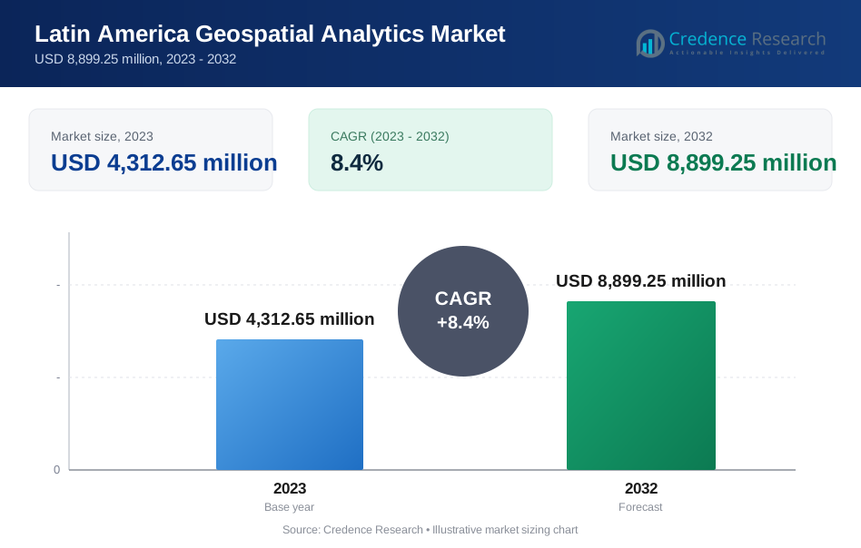
Latin America Geospatial Analytics Market size was valued at USD 4,312.65 million in 2023 and is anticipated to reach USD 8,899.25 million by 2032, at a CAGR of 8.4% during the forecast period (2023-2032).
Several factors are propelling the expansion of the geospatial analytics market in Latin America. Foremost among these is the supportive stance of governments, which are implementing favorable policies and making significant investments in geospatial infrastructure. The proliferation of location-based services (LBS) across industries such as retail, transportation, healthcare, and agriculture is also a key driver, as these services leverage real-time geospatial data to enhance decision-making processes. Additionally, the integration of advanced technologies like artificial intelligence (AI), Internet of Things (IoT), and cloud computing is enhancing the capabilities and applications of geospatial analytics, thereby attracting further investment and adoption.
Within Latin America, Brazil stands out as a significant contributor to the geospatial analytics market, expected to register the highest CAGR from 2025 to 2030. The country's burgeoning construction sector, driven by a substantial housing deficit, is increasingly relying on geospatial data to identify optimal investment locations and streamline urban planning. Moreover, initiatives like GeoSUR, a regional program led by the Development Bank of Latin America and the Pan-American Institute of Geography and History, are fostering the development of a regional geospatial network. GeoSUR aims to establish a spatial data infrastructure by supporting the creation of free-access geographic services, thereby facilitating the dissemination and utilization of spatial information across Latin America and the Caribbean. These collaborative efforts are instrumental in enhancing data accessibility and promoting the widespread adoption of geospatial analytics throughout the region.
Market Insights:
- The Latin America Geospatial Analytics Market was valued at USD 4,312.65 million in 2023 and is expected to reach USD 8,899.25 million by 2032, growing at a CAGR of 8.4% during the forecast period.
- Government initiatives, such as GeoSUR, are playing a pivotal role by providing favorable policies, investments, and spatial data infrastructure, which is driving market expansion.
- The growing adoption of location-based services (LBS) in industries like retail, transportation, and healthcare is significantly increasing the demand for geospatial analytics in the region.
- Urbanization and the modernization of infrastructure across Latin American cities are fostering the need for geospatial analytics in urban planning, traffic management, and resource allocation.
- The integration of advanced technologies, such as artificial intelligence (AI), IoT, and cloud computing, is enhancing the capabilities of geospatial analytics, driving further market growth.
- Environmental monitoring and agricultural applications, including crop monitoring and deforestation tracking, are increasingly dependent on geospatial technologies to address sustainability challenges in the region.
- Challenges like high implementation costs, data fragmentation, and concerns over data privacy and security are slowing down market adoption, requiring more regional collaboration and stronger data governance frameworks.
Report Scope
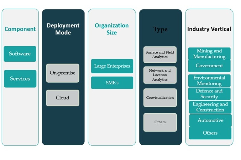
This report segments Latin America Geospatial Analytics Market as follow;
Market Drivers:
Government Support and Infrastructure Development
Governments across Latin America are playing a pivotal role in driving the growth of the geospatial analytics market by implementing favorable regulatory frameworks and investing in technological infrastructure. Several national and regional initiatives are focused on integrating geospatial technologies into governance, environmental monitoring, and urban development. For instance, the GeoSUR program, coordinated by the Development Bank of Latin America and supported by national mapping agencies, has developed a regional spatial data infrastructure (SDI) that features over 300 Open Geospatial Consortium (OGC)-compliant services, 14,000 harvested metadata records, 220,000 searchable metadata records, and 110 map viewers. These initiatives aim to improve the accessibility and quality of geographic data, thereby facilitating informed decision-making in public policy and planning. This institutional backing not only promotes the use of geospatial analytics but also fosters collaborations between public and private sectors, further expanding the market’s scope.
Adoption of Location-Based Services and Smart Technologies
The rapid adoption of location-based services (LBS) is significantly boosting the demand for geospatial analytics in Latin America. For instance, companies like Predict Data-driven have used location analytics to analyze foot traffic and consumer mobility patterns within shopping malls in Guatemala, helping retailers optimize store layouts and marketing strategies. Industries such as retail, logistics, transportation, and healthcare are leveraging LBS to optimize operations, enhance customer engagement, and streamline service delivery. With the proliferation of smartphones, GPS-enabled devices, and mobile applications, there has been a sharp increase in the generation and consumption of geospatial data. Additionally, the integration of geospatial analytics with smart technologies like the Internet of Things (IoT) and connected infrastructure is enabling real-time tracking, predictive analytics, and automation. This convergence of technologies is encouraging businesses to invest in advanced analytics platforms to derive actionable insights from spatial data.
Urbanization and Infrastructure Modernization
The growing pace of urbanization across Latin America is fueling the need for effective spatial planning and infrastructure modernization. Major metropolitan areas are grappling with challenges related to population density, transportation networks, utility management, and environmental sustainability. Geospatial analytics offers valuable tools for urban planners and municipal authorities to design, monitor, and manage city resources efficiently. From zoning and land use planning to traffic flow analysis and waste management, spatial intelligence is becoming an integral component of urban governance. Countries like Brazil, Mexico, and Colombia are investing in smart city initiatives where geospatial technologies play a central role in building resilient and efficient urban systems.
Environmental and Agricultural Applications
Environmental monitoring and sustainable agricultural practices represent another key driver of the geospatial analytics market in Latin America. The region’s diverse ecosystems and dependence on agriculture for economic stability necessitate accurate and timely data for land use management, crop monitoring, deforestation tracking, and disaster response. Geospatial tools such as remote sensing, satellite imagery, and GIS are increasingly used to assess soil health, predict crop yields, and mitigate the effects of climate change. These capabilities are critical for enhancing food security and ensuring ecological conservation. Governments, research institutions, and agribusinesses are jointly investing in geospatial solutions to improve productivity and environmental stewardship, reinforcing the value of these tools in addressing regional challenges.
Market Trends:
Integration with Artificial Intelligence and Machine Learning
One of the most significant trends shaping the Latin America geospatial analytics market is the integration of artificial intelligence (AI) and machine learning (ML) into geospatial platforms. These technologies are enhancing the analytical depth of spatial data by enabling predictive modeling, automated classification of satellite imagery, and anomaly detection. AI-powered geospatial analytics is particularly beneficial for industries such as disaster management, forestry, and mining, where vast datasets require real-time interpretation. Companies are deploying AI-enabled tools to improve operational efficiency, reduce manual workloads, and gain insights that were previously difficult to uncover. As these technologies mature, their adoption across public and private sectors in Latin America is expected to increase steadily.
Expansion of Cloud-Based Geospatial Solutions
The transition from traditional on-premise GIS systems to cloud-based geospatial solutions is a notable trend driving market transformation in Latin America. For instance, the Geographic Institute of El Salvador became the first mapping agency in the region to operate a service in the Amazon Cloud using ArcGIS for Server, with GeoSUR assisting 10 other partners in similar transitions. Cloud platforms offer greater scalability, lower infrastructure costs, and easier access to real-time spatial data. This is particularly advantageous for SMEs and regional agencies that face budgetary constraints but still require robust analytical capabilities. Cloud-based systems also enable seamless integration with other enterprise applications such as CRM, ERP, and business intelligence tools. Leading cloud providers are partnering with geospatial firms to deliver customized solutions tailored to Latin American markets, further accelerating adoption across sectors like utilities, environmental monitoring, and logistics.
Growing Application in Climate Resilience and Sustainability
Geospatial analytics is increasingly being used in Latin America to address climate-related challenges and support sustainability goals. The region is highly vulnerable to climate events such as floods, droughts, and wildfires, which necessitates advanced monitoring and early warning systems. For example, municipalities like San Benito (Argentina), Ambato (Ecuador), and Rio de Janeiro (Brazil) have presented their experiences using GIS to strengthen climate planning, manage vulnerability to extreme weather, and implement sustainable local initiatives. Spatial data, when combined with environmental indicators, enables authorities to implement targeted disaster response and mitigation strategies. Additionally, sustainability initiatives related to renewable energy site selection, carbon emission tracking, and biodiversity preservation are relying on geospatial tools for accurate assessments. These applications are not only gaining prominence among government agencies but also among non-governmental organizations and climate-focused startups.
Rise of Location Intelligence in Commercial Sectors
Location intelligence is gaining traction in the commercial sector, particularly in retail, telecommunications, and real estate industries. Businesses are leveraging spatial analytics to understand consumer behavior, optimize site selection, and refine marketing strategies. In the retail domain, geospatial insights are helping companies map customer density, assess competitive presence, and plan distribution networks more efficiently. Telecommunications providers are using these tools to design network expansions based on population distribution and terrain analysis. Meanwhile, real estate developers are employing location intelligence to evaluate property value trends and infrastructure availability. This growing demand for commercial applications is fostering innovation and widening the scope of the geospatial analytics market in Latin America.
Market Challenges Analysis:
High Implementation Costs and Technical Complexity
Implementing geospatial analytics in Latin America involves substantial upfront investments in high-resolution satellite imagery, LiDAR equipment, advanced GIS software, and robust data storage and processing infrastructure. For example, organizations often face significant expenses not only for initial system acquisition but also for ongoing operational costs such as software updates, maintenance, and the training of skilled personnel. Integrating these advanced technologies with existing IT systems is technically complex and frequently necessitates hiring specialists, which further increases financial strain. According to industry analysis, these high costs and technical barriers are particularly challenging for small and medium-sized enterprises and public sector institutions with limited budgets, often delaying or preventing adoption of geospatial analytics solutions.
Data Availability and Standardization Issues
Another key challenge lies in the availability, accessibility, and standardization of spatial data across Latin American countries. Inconsistent data collection methods, fragmented data ownership, and lack of interoperability between different platforms often result in data silos. This fragmentation limits the ability of organizations to derive comprehensive insights from geospatial analytics. Additionally, the lack of centralized data repositories and real-time data sharing mechanisms constrains regional collaboration. Efforts to build open-access geospatial databases have shown progress but remain insufficient to meet growing analytical demands.
Concerns Over Data Privacy and Security
Data privacy and cybersecurity concerns are also impeding market expansion. As geospatial analytics increasingly relies on real-time location tracking and personal data, the potential for misuse or data breaches poses a significant risk. In regions where data protection regulations are either underdeveloped or inconsistently enforced, organizations face legal and ethical uncertainties. This discourages widespread deployment of geospatial applications, especially in sectors handling sensitive data such as healthcare and public safety. Addressing these issues will require stronger legal frameworks, clearer data governance policies, and heightened investment in cybersecurity solutions tailored to geospatial environments.
Market Opportunities:
The Latin America geospatial analytics market presents significant growth opportunities driven by the region’s digital transformation and increasing demand for spatial intelligence across industries. With expanding urban populations and rising infrastructure needs, governments are investing in smart city initiatives that depend heavily on geospatial tools for urban planning, traffic management, and public service optimization. These initiatives create a conducive environment for the integration of GIS, satellite imagery, and real-time location data into public infrastructure and utilities. Additionally, sectors such as agriculture and forestry, which form a large part of Latin America’s economy, are increasingly adopting geospatial analytics to enhance productivity, monitor natural resources, and mitigate the impacts of climate change. The use of precision agriculture and environmental monitoring systems offers vast potential for geospatial technology providers to tailor solutions that meet the region’s unique needs.
Moreover, the increasing availability of cloud-based geospatial solutions is democratizing access for small and medium-sized enterprises, expanding the market beyond large-scale industrial and governmental use. The commercial sector particularly retail, real estate, logistics, and telecommunications is also realizing the value of location intelligence for strategic decision-making. As e-commerce and mobile connectivity grow across Latin America, businesses are leveraging geospatial analytics to optimize logistics, enhance customer targeting, and improve operational efficiency. Coupled with advances in AI, IoT, and big data analytics, the market stands poised for rapid evolution, offering ample opportunity for domestic and international vendors to expand their footprint through localized, scalable, and interoperable geospatial solutions.
Market Segmentation Analysis:
The Latin America geospatial analytics market is segmented across several key dimensions, reflecting the diverse applications and evolving technological needs within the region.
By component, the software segment holds the largest market share, driven by the rising demand for advanced GIS, remote sensing, and spatial modeling platforms. However, the services segment is growing steadily as organizations increasingly seek consulting, integration, and support services to manage complex deployments and ensure optimal system performance.
By deployment mode, cloud-based geospatial analytics solutions are witnessing accelerated adoption, especially among SMEs due to their scalability, lower upfront costs, and ease of integration. Nevertheless, the on-premise segment remains relevant for large enterprises and government agencies prioritizing data sovereignty and security.
By organization size, large enterprises dominate the market due to their robust IT infrastructure and capacity to invest in cutting-edge geospatial technologies. However, the SME segment is gaining momentum, supported by affordable cloud offerings and government initiatives promoting digital transformation.
By type, network and location analytics represent the largest share owing to their extensive use in transportation, logistics, and telecom sectors. Surface and field analytics and geovisualization are also growing, particularly in industries requiring real-time spatial monitoring and decision support.
By industry verticals, the government sector leads adoption due to applications in urban planning, resource mapping, and security. Environmental monitoring and engineering and construction follow closely, driven by sustainability initiatives and infrastructure development. Mining, manufacturing, and automotive sectors are also leveraging geospatial tools to enhance operational efficiency and strategic planning.
Segmentation:
By Component:
- Software
- Services
By Deployment Mode:
- On-premise
- Cloud
By Organization size:
- Large Enterprises
- SME’s
By Type:
- Surface and Field Analytics
- Network and Location Analytics
- Geovisualization
- Others
By Industry Vertical:
- Mining and Manufacturing
- Government
- Environmental Monitoring
- Defence and Security
- Engineering and Construction
- Automotive
- Others
Regional Analysis:
The Latin America geospatial analytics market is experiencing robust growth, driven by increasing demand for spatial data applications across various sectors
Brazil: Leading the Regional Market
Brazil stands as the dominant force in the Latin American geospatial analytics market, accounting for approximately 35% of the regional market share. The country's burgeoning construction sector, driven by a substantial housing deficit, is increasingly relying on geospatial data to identify optimal investment locations and streamline urban planning. Notably, GIS/spatial analytics emerged as the largest revenue-generating segment in 2024, while 3D scanning is anticipated to be the fastest-growing technology segment through 2030.
Mexico: Embracing Geospatial Technologies
Mexico holds a significant position in the Latin American geospatial analytics market, contributing around 25% to the regional market share. The country's government and private sectors are increasingly adopting geospatial technologies for applications in urban planning, transportation, and environmental monitoring. The integration of geospatial analytics with smart city initiatives is particularly notable, aiming to enhance infrastructure development and service delivery.
Argentina: Growing Adoption Across Sectors
Argentina accounts for approximately 15% of the Latin American geospatial analytics market. The country is witnessing growing adoption of geospatial technologies across various sectors, including agriculture, defense, and environmental monitoring. Government initiatives to modernize infrastructure and improve disaster management are further propelling the demand for geospatial analytics solutions.
Other Latin American Countries: Emerging Opportunities
The remaining 25% of the Latin American geospatial analytics market is distributed among other countries in the region, such as Colombia, Chile, and Peru. These countries are emerging as promising markets due to increasing investments in infrastructure development, environmental conservation, and digital transformation initiatives. The adoption of cloud-based geospatial solutions and the integration of artificial intelligence and machine learning technologies are expected to drive market growth in these nations.
Key Player Analysis:
- Geosistemas
- Exatas
- Satellogic
- SPOT Image
- General Electric
- SAP SE
- Google, Inc.
- Bentley Systems, Incorporated
- Alteryx, Inc.
- Oracle Corporation
- TOMTOM International, Inc.
- Hexagon AB
- Trimble, Inc.
- Esri
- Microsoft Corporation
- Others
Competitive Analysis:
The Latin America geospatial analytics market features a competitive landscape characterized by the presence of global technology providers and regional players offering specialized solutions. Key international firms such as Esri, Hexagon AB, Trimble Inc., and IBM dominate the market with robust product portfolios and extensive R&D capabilities. These companies are enhancing their market presence through strategic partnerships, regional collaborations, and cloud-based offerings tailored for Latin American clients. Meanwhile, local and regional firms are gaining traction by offering cost-effective and customized services, particularly in sectors such as urban planning, agriculture, and environmental monitoring. The competitive focus is shifting toward innovation in AI-driven geospatial platforms, user-friendly interfaces, and scalable cloud-based solutions. As demand for spatial intelligence continues to grow across industries, companies are intensifying efforts to expand their footprint, improve data integration capabilities, and meet region-specific requirements, creating a dynamic and evolving competitive environment.
Recent Developments:
- In May 2024, Geosistemas Engenharia e Defesa was selected to design the Salgueiro–Suape section of the Transnordestina railway in Brazil, marking a significant infrastructure project in the region's transportation and geospatial analytics landscape.
- In May 2023, Intermap Technologies announced a partnership with GeoSolutions to provide high-resolution elevation data and imagery correction services for government development projects in El Salvador and Honduras, Central America. This collaboration aims to enable the creation of precision maps that support community safety and resiliency, marking a significant development in the geospatial analytics landscape of Latin America
- In March 2023, Mach9 launched its first product designed to accelerate geospatial data processing and analysis for infrastructure management. The new solution leverages computer vision and AI to produce faster 2D and 3D CAD and GIS engineering deliverables, responding to the rising demand for advanced geospatial analytics tools in the region.
Market Concentration & Characteristics:
The Latin America geospatial analytics market exhibits moderate market concentration, with a mix of dominant global firms and a growing number of regional and niche players. Major international companies such as Esri, Trimble Inc., and Hexagon AB maintain a strong foothold through well-established distribution networks, comprehensive product offerings, and strategic partnerships with local governments and enterprises. However, the market also accommodates emerging domestic players that cater to specific industry needs and regional challenges. The market is characterized by increasing demand for cloud-based analytics, integration with AI and IoT technologies, and a shift toward real-time, mobile-enabled platform. Government-backed smart infrastructure initiatives, rising environmental concerns, and the growing emphasis on digital transformation further shape the market’s dynamics. While larger enterprises dominate initial adoption, SMEs are increasingly adopting scalable solutions, expanding the customer base. This evolving environment fosters innovation and competition, driving the market toward greater technological sophistication and regional diversification.
Report Coverage:
The research report offers an in-depth analysis based on Component, Deployment Mode, Organization size, Type and Industry Vertical. It details leading market players, providing an overview of their business, product offerings, investments, revenue streams, and key applications. Additionally, the report includes insights into the competitive environment, SWOT analysis, current market trends, as well as the primary drivers and constraints. Furthermore, it discusses various factors that have driven market expansion in recent years. The report also explores market dynamics, regulatory scenarios, and technological advancements that are shaping the industry. It assesses the impact of external factors and global economic changes on market growth. Lastly, it provides strategic recommendations for new entrants and established companies to navigate the complexities of the market.
Future Outlook:
- The market is projected to witness strong growth, driven by increased demand for spatial data across infrastructure, agriculture, and urban planning sectors.
- Ongoing investments in smart city development will amplify the use of geospatial tools in municipal planning and public services.
- Cloud-based analytics platforms will gain prominence, offering scalability and cost-efficiency for SMEs and public agencies.
- Integration of AI and machine learning will enhance predictive capabilities and automate spatial data analysis.
- Environmental monitoring applications will expand, supporting climate resilience and disaster management strategies.
- Government initiatives and public-private partnerships will play a crucial role in improving spatial data accessibility.
- Cross-sector demand, particularly from logistics, real estate, and telecom, will fuel commercial adoption.
- Increasing mobile connectivity and IoT proliferation will support real-time location-based insights.
- Data privacy regulations and interoperability standards will evolve to address regional governance challenges.
- Local solution providers will emerge as key players by offering region-specific, cost-effective services.
Request a Free Sample
Fill in your details and we'll send you a free sample report.
- Sample data tables & charts
- Research methodology
Need a Custom Version of This Report?
Tailor the scope, geography, or segments to your exact requirements.
- Custom geography or segment scope
- Direct access to our analyst team
Frequently Asked Questions
What is the current size of the Latin America Geospatial Analytics Market?
What factors are driving the growth of the Latin America Geospatial Analytics Market?
What are some challenges faced by the Latin America Geospatial Analytics Market?
Who are the major players in the Latin America Geospatial Analytics Market?
Table of Content
Chapter 1. Report Introduction
- 1.1 Report Description & Purpose
- 1.1.1 Report Title & Market Definition
- 1.1.2 Unique Selling Propositions (USP) & Key Differentiators
- 1.1.3 Value Proposition for Stakeholders
- 1.2 Research Objectives
- 1.2.1 Market Sizing Objectives (Volume & Revenue)
- 1.2.2 Segmentation Objectives
- 1.2.3 Competitive Intelligence Objectives
- 1.2.4 Forecast & Scenario Objectives
- 1.3 Report Scope
- 1.3.1 Latin America Geospatial Analytics Scope – Types & Subtypes Covered
- 1.3.2 Geographic Scope – Regions & Countries Covered
- 1.3.3 Historical Period, Base Year & Forecast Period (2023; forecast to 2032)
- 1.3.4 Inclusions & Exclusions
- 1.4 HS Code & Classification Framework
- 1.5 Currency, Units & Pricing Basis
- 1.6 Target Stakeholders
- 1.7 Limitations & Assumptions
Chapter 2. Executive Summary
- 2.1 Global Latin America Geospatial Analytics Market Snapshot
- 2.1.1 Market Size – Historical (2023) & Forecast (2023-2032) (2023: USD 4,312.65 million → 2032: USD 8,899.25 million)
- 2.1.2 Volume & Revenue – Global Totals
- 2.1.3 Key Market Highlights – Top Five Facts
- 2.2 Latin America Geospatial Analytics Market Segmentation Snapshot
- 2.2.1 Market Split by Region – 2023 vs. 2032
- 2.3 Competitive Snapshot
- 2.3.1 Top 10 Players by Revenue Share – 2023
- 2.3.2 Top 10 Players by Volume Share – 2023
- 2.3.3 Recent Strategic Developments (18-Month Summary)
- 2.4 Key Investment Highlights & Strategic Conclusions
Chapter 3. Latin America Geospatial Analytics Market Dynamics & Industry Analysis
- 3.1 Market Overview & Context
- 3.1.1 Latin America Geospatial Analytics Market Position in the Broader Automotive Value Chain
- 3.1.2 OEM vs. Replacement Market Dynamics
- 3.1.3 Market Maturity & Development Stage by Region
- 3.2 Latin America Geospatial Analytics Market Drivers
- 3.3 Latin America Geospatial Analytics Market Restraints & Challenges
- 3.4 Latin America Geospatial Analytics Market Opportunities
- 3.5 Porter's Five Forces Analysis
- 3.5.1 Threat of New Entrants
- 3.5.2 Bargaining Power of Suppliers
- 3.5.3 Bargaining Power of Buyers
- 3.5.4 Threat of Substitutes
- 3.5.5 Competitive Rivalry – Intensity Assessment
- 3.6 Latin America Geospatial Analytics Value Chain Analysis
- 3.6.1 Upstream – Raw Material/Input Suppliers
- 3.6.1.1 Raw Material/Input 1
- 3.6.1.2 Raw Material/Input 2
- 3.6.1.3 Raw Material/Input 3
- 3.6.2 Midstream – Production/Manufacturing/Service Delivery
- 3.6.2.1 Production/Process Overview
- 3.6.2.2 Key Facility Locations & Capacity by Manufacturer
- 3.6.3 Downstream – Distribution & End Consumer
- 3.6.3.1 Primary Channel – B2B/OEM
- 3.6.3.2 Secondary Channels – Dealer, Retail, Online, Direct
- 3.6.4 Value Chain Profitability Analysis
- 3.6.1 Upstream – Raw Material/Input Suppliers
- 3.7 PESTEL Analysis
- 3.7.1 Political Factors
- 3.7.2 Economic Factors
- 3.7.3 Social Factors
- 3.7.4 Technological Factors
- 3.7.5 Environmental Factors
- 3.7.6 Legal Factors
- 3.8 Latin America Geospatial Analytics Supply Chain Analysis
- 3.8.1 Raw Material/Input Supply Risk Assessment
- 3.8.2 Manufacturing Concentration Risk (Geographic Exposure)
- 3.8.3 Trade Disruption Impact Analysis
- 3.9 Regulatory & Policy Landscape
Note: The regulatory and policy landscape section covers regulations based on their applicability to the market, Latin America Geospatial Analytics category, geography, and scope of the study. Only regulatory frameworks with a material impact on operations, compliance, trade, sustainability, or market access are analyzed in detail.
Chapter 4. Key Investment Pockets & Opportunity Analysis
- 4.1 Latin America Geospatial Analytics Market Attractiveness Analysis
- 4.1.1 By Region – Investment Attractiveness Matrix (Volume × CAGR)
- 4.2 Absolute Revenue Growth Opportunity
- 4.2.1 By Region – Absolute USD Growth Through 2032
- 4.3 Incremental Volume Opportunity
- 4.3.1 By Region – Incremental Volume Through 2032
- 4.3.2 Segment – Incremental Volume
- 4.4 Emerging Submarket Opportunity Deep Dive (Subject to Applicability)
- 4.5 Emerging Market Opportunity Scorecards
- 4.5.1 United States
- 4.5.2 Europe
- 4.5.3 Asia
- 4.5.4 Middle East & Africa
Note: Emerging Market Opportunity Scorecards will be included based on relevance and strategic importance. Regions listed are indicative and may vary depending on data availability and market dynamics.
Chapter 5. Latin America Geospatial Analytics Import-Export Analysis & Trade Flows
- 5.1 Global Trade Overview
- 5.1.1 Global Export Value by Country (2023)
- 5.1.2 Global Export Volume by Country (2023)
- 5.1.3 Global Import Value by Country (2023)
- 5.1.4 Global Import Volume by Country (2023)
- 5.1.5 Net Trade Balance by Country (2023)
- 5.2 Export Analysis – Segment
- 5.2.1 Type 1 (HS Code)
- 5.2.2 Type 2 (HS Code)
- 5.2.3 Type 3 (HS Code)
- 5.2.4 Type 4 (HS Code)
- 5.2.5 Type 5 (HS Code)
- 5.3 Import Analysis – Segment
- 5.3.1 Type 1 (HS Code)
- 5.3.2 Type 2 (HS Code)
- 5.3.3 Type 3 (HS Code)
- 5.3.4 Type 4 (HS Code)
- 5.3.5 Type 5 (HS Code)
- 5.4 Average Unit Trade Prices
- 5.4.1 Average Export Price – Segment & Country
- 5.4.2 Average Import Price – Segment & Source Country
- 5.4.3 Price Trends (2023)
- 5.5 Key Trade Route Analysis
- 5.5.1 Trade Route 1
- 5.5.2 Trade Route 2
- 5.5.3 Trade Route 3
- 5.5.4 Trade Route 4
- 5.5.5 Trade Route 5
- 5.6 Trade Policy Impact Assessment
- 5.6.1 US Anti-Dumping & Section 301 Tariffs
- 5.6.2 EU Customs Union Impact
- 5.6.3 Major Free Trade Agreements
- 5.6.4 USMCA Rules of Origin
Note: Trade policy analysis will be included only where relevant to the Latin America Geospatial Analytics market.
Chapter 6. Competitive Landscape & Company Benchmarking
- 6.1 Latin America Geospatial Analytics Market Concentration & Structure
- 6.1.1 Herfindahl-Hirschman Index (HHI) – vs. 2023
- 6.1.2 Tier 1, Tier 2 & Tier 3 Market Structure
- 6.1.3 Global, Regional & Local Player Dynamics
- 6.2 Latin America Geospatial Analytics Market Share Analysis – 2023
- 6.2.1 Global Revenue Share by Company
- 6.2.2 Global Volume Share by Company
- 6.2.3 Regional Revenue Share
- 6.2.4 Market Share Evolution ( vs. 2023)
- 6.2.5 OEM Segment Share by Company
- 6.2.6 Replacement Segment Share by Company
- 6.3 Production/Delivery Capacity & Facility Analysis
- 6.3.1 Global Installed Capacity
- 6.3.2 Capacity Utilization Rates
- 6.3.3 Production/Output Volume
- 6.3.4 Facility Locations & Capacity Map
- 6.3.5 Planned Capacity Additions
- 6.4 Latin America Geospatial Analytics Competitive Benchmarking Matrix
- 6.4.1 Revenue, Volume, CAGR & Profitability Comparison
- 6.4.2 Channel Revenue Mix
- 6.4.3 Geographic Revenue Exposure
- 6.4.4 R&D Intensity
- 6.4.5 Sustainability Maturity
- 6.5 Strategic Developments in Latin America Geospatial Analytics (Last 24 Months)
- 6.5.1 Mergers, Acquisitions & Divestments
- 6.5.2 New Latin America Geospatial Analytics Launches
- 6.5.3 Facility Expansions
- 6.5.4 Strategic Alliances, Joint Ventures & Partnerships
- 6.5.5 Distribution Expansion & Market Entry
- 6.5.6 Sustainability & ESG Initiatives
- 6.6 Competitive Strategy Mapping
- 6.6.1 Leader, Challenger, Follower & Niche Classification
- 6.6.2 Pricing Strategy Comparison
- 6.6.3 Channel Strategy Matrix
Note: Strategic developments are included based on their materiality and the availability of reliable information.
Chapter 7. Global Latin America Geospatial Analytics Market – By Distribution Channel
- 7.1 Segment Overview
- 7.1.1 Volume & Revenue Split by Channel (2023 & 2032)
- 7.1.2 Channel Mix Evolution (2023-2032)
Chapter 8. Regional Market Analysis – Global Overview
- 8.1 Global Regional Overview
- 8.1.1 Regional Volume Share
- 8.1.2 Regional Revenue Share
- 8.1.3 Regional Volume by Region
- 8.1.4 Regional Revenue by Region
- 8.1.5 Regional Forecast Through 2032
- 8.2 Cross-Regional Segment Analysis
- 8.2.1 By Distribution Channel
- 8.2.2 By Brand/Price Tier
Chapter 9. North America Latin America Geospatial Analytics Market
- 9.1 United States
- 9.2 Canada
- 9.3 Mexico
Chapter 10. Europe Latin America Geospatial Analytics Market
- 10.1 Germany
- 10.2 France
- 10.3 Italy
- 10.4 United Kingdom
- 10.5 Spain
- 10.6 Poland
- 10.7 Russia
- 10.8 Netherlands
- 10.9 Belgium
- 10.10 Sweden
- 10.11 Denmark
- 10.12 Norway
- 10.13 Rest of Europe
Chapter 11. Asia Pacific Latin America Geospatial Analytics Market
- 11.1 China
- 11.2 India
- 11.3 Japan
- 11.4 South Korea
- 11.5 Thailand
- 11.6 Indonesia
- 11.7 Vietnam
- 11.8 Malaysia
- 11.9 Australia
- 11.10 Rest of Asia Pacific
Chapter 12. Latin America Latin America Geospatial Analytics Market
- 12.1 Brazil
- 12.2 Argentina
- 12.3 Colombia
- 12.4 Chile
- 12.5 Rest of Latin America
Chapter 13. Middle East Latin America Geospatial Analytics Market
- 13.1 Saudi Arabia
- 13.2 United Arab Emirates
- 13.3 Turkey
- 13.4 Israel
- 13.5 Iran
- 13.6 Rest of the Middle East
Chapter 14. Africa Latin America Geospatial Analytics Market
- 14.1 South Africa
- 14.2 Egypt
- 14.3 Nigeria
- 14.4 Morocco
- 14.5 Rest of Africa
Chapter 15. Latin America Geospatial Analytics Company Profiles
- 15.1 [Company 01]
- 15.1.1 Company Overview
- 15.1.2 Key Management Personnel
- 15.1.3 Products & Services Portfolio
- 15.1.4 Financial Performance
- 15.1.5 Key Market Focus & Geographic Presence
- 15.1.6 Recent Developments & Strategic Initiatives
Note: The company profile list is preliminary and may change based on research findings, market developments, data availability, and client requirements.
Chapter 16. Appendices
- Appendix A – List of Abbreviations & Acronyms
- Appendix B – Industry Classification Code Reference – Full Series
- Appendix C – Production & Capacity Data Tables
- Appendix D – End-Use & Demand Base Tables
- Appendix E – Consumption & Replacement Rate Assumptions
- Appendix F – ASP Reference Tables
- Appendix G – Manufacturing & Facility Database
- Appendix H – Import-Export Data Tables
- Appendix I – Regulatory Summary Tables
- Appendix J – Primary Research Participant List (Anonymized)
- Appendix K – Primary Research Questionnaire Framework
- Appendix L – Data Sources & Bibliography
- Appendix M – Market Size Divergence & Source Comparison
Chapter 17. Research Methodology
- 17.1 Research Framework & Philosophy
- 17.2 Secondary Research – Sources, Hierarchy & Data Extraction
- 17.3 Data Modeling – Bottom-Up & Top-Down Market Sizing
- 17.4 Primary Research – Stakeholder Framework, LOI & Sample Sizes
- 17.5 Forecast Methodology – Regression, Scenario & Sensitivity Analysis
- 17.6 Quality Control – Four-Layer Validation Framework
- 17.7 Limitations & Standard Assumptions
- 17.8 Disclaimer