Home » Information and Communications Technology » Technology & Media » Canada Geospatial Analytics Market

Canada Geospatial Analytics Market

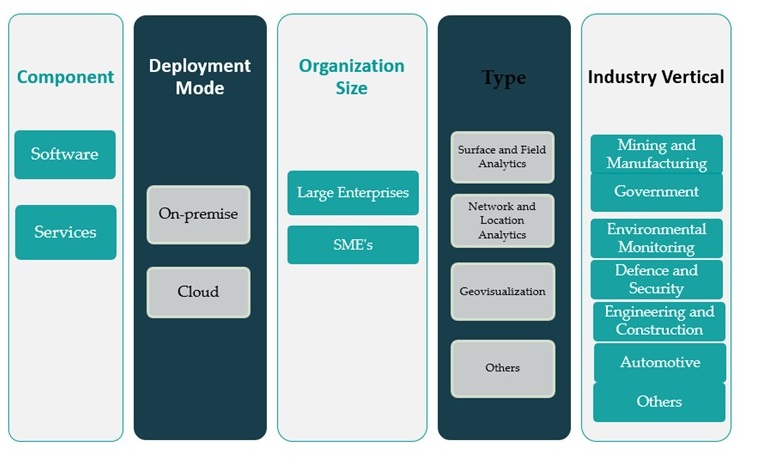
Canada Geospatial Analytics Market By Component (Software, Services); By Deployment Mode (On-premise, Cloud); By Organization Size (Large Enterprises, SMEs); By Type (Surface and Field Analytics, Network and Location Analytics, Geovisualization, Others); By Industry Vertical (Mining and Manufacturing, Government, Environmental Monitoring, Defence and Security, Engineering and Construction, Automotive, Others) – Growth, Share, Opportunities & Competitive Analysis, 2024 – 2032

Price: $2699

Published: | Report ID: 93100 | Report Format : Excel, PDF
REPORT ATTRIBUTE DETAILS
Historical Period 2020-2023
Base Year 2024
Forecast Period 2025-2032
Canada Geospatial Analytics Market Size 2023 USD 2,865.20 million
Canada Geospatial Analytics Market, CAGR 8.8%
Canada Geospatial Analytics Market Size 2032 USD 6,124.64 million

Market Overview:

Canada Geospatial Analytics Market size was valued at USD 2,865.20 million in 2023 and is anticipated to reach USD 6,124.64 million by 2032, at a CAGR of 8.8% during the forecast period (2023-2032).

Several factors are driving the growth of the geospatial analytics market in Canada. A key contributor is the Canadian government’s proactive approach toward infrastructure modernization and digital transformation. National initiatives involving smart city development, climate monitoring, and natural resource management are heavily reliant on geospatial data, which enhances strategic planning and operational efficiency. Moreover, technological advancements in Geographic Information Systems (GIS), remote sensing, cloud platforms, and spatial data processing tools have significantly improved the accuracy, usability, and integration of geospatial analytics. These innovations have lowered the barrier to entry for businesses across various sectors, enabling broader adoption. In the agricultural sector, for instance, geospatial analytics is used extensively for precision farming, crop health monitoring, and land use optimization. Similarly, the defense sector employs these tools for surveillance, mission planning, and threat detection. The environmental sector leverages geospatial data for ecosystem management, deforestation tracking, and climate risk assessment.

Regionally, Ontario dominates the Canadian geospatial analytics landscape due to its strong technology ecosystem, dense urban infrastructure, and high level of government and enterprise investment in digital tools. The Toronto-Waterloo corridor stands out as a technological innovation hub where startups, universities, and large enterprises collaborate on geospatial research and solutions. Ontario’s extensive urban development and transportation projects also contribute to higher adoption rates of geospatial technologies in infrastructure planning and traffic management. Alberta is another key region witnessing substantial growth, driven by the province’s focus on natural resource management and environmental sustainability. With vast forest areas and energy sector activities, Alberta employs geospatial analytics for monitoring land use, managing pipelines, and assessing environmental impacts. British Columbia is gaining traction as well, especially in forestry and marine conservation efforts. Its rugged terrain and ecological diversity require constant geospatial analysis to support sustainable development and natural disaster response.

Design Element 2

Access crucial information at unmatched prices!

Request your sample report today & start making informed decisions powered by Credence Research!

Download Sample

CTA Design Element 3

Market Insights:

  • The Canada Geospatial Analytics Market was valued at USD 2,865.20 million in 2023 and is projected to reach USD 6,124.64 million by 2032, expanding at a CAGR of 8.8%.
  • Government-driven initiatives in smart city planning, climate monitoring, and natural resource management continue to be primary catalysts for geospatial technology adoption.
  • Rapid technological advancements in GIS, AI, remote sensing, and cloud platforms are significantly enhancing data accuracy, integration, and real-time analytical capabilities.
  • Applications across agriculture, energy, urban development, logistics, and retail are broadening, with precision farming and infrastructure monitoring emerging as key growth areas.
  • Environmental monitoring and disaster preparedness are becoming central use cases, particularly in response to increasing climate volatility and ecological risks.
  • Key barriers include data privacy regulations under frameworks like PIPEDA and the high cost of deployment, which limits entry for SMEs and delays broader adoption.
  • Ontario leads the market regionally with a 38% share, followed by Alberta and British Columbia, supported by strong technology ecosystems and sector-specific demands.

Report Scope

This report segments the Canada Geospatial Analytics Market as follow

Canada Geospatial Analytics Market

Market Drivers:

Government Initiatives and Public Sector Adoption

One of the primary drivers accelerating the growth of the Canada geospatial analytics market is the strong commitment of federal and provincial governments to digital transformation and data-driven decision-making. Numerous public sector initiatives are utilizing geospatial technologies for infrastructure planning, emergency response, climate monitoring, and smart city development. Government departments and agencies, for instance, Natural Resources Canada (NRCan) operates GEO.ca, which provides access to over 7,000 geospatial datasets from more than 40 contributors, supporting infrastructure planning, emergency response, and climate monitoring. Additionally, funding programs and open data initiatives are enhancing the accessibility of geospatial datasets, encouraging greater adoption across municipalities and private sectors. The public sector’s leadership in integrating geospatial analytics into national planning frameworks creates a ripple effect that encourages wider commercial adoption.

Advancements in Technology and Integration Capabilities

Rapid technological advancements in geospatial analytics tools, particularly in Geographic Information Systems (GIS), remote sensing, and cloud computing, are enhancing the precision, scalability, and utility of spatial data. For example, GEO Analytics Canada has developed a cloud-native, open platform for big data geoscience, enabling dynamic scaling and close-to-the-data processing for large datasets such as Landsat and Sentinel imagery. Canadian firms and research institutions are actively developing solutions that integrate these technologies with Artificial Intelligence (AI), Machine Learning (ML), and Big Data analytics, which significantly expand the analytical capabilities of geospatial platforms. These integrations enable real-time monitoring, predictive modeling, and automated pattern recognition, which are crucial for applications ranging from urban mobility to climate resilience. Moreover, cloud-based platforms offer improved accessibility and cost-efficiency, allowing small and medium enterprises to implement geospatial analytics without significant upfront investments. The convergence of these technologies supports faster, more informed decision-making and fuels overall market expansion.

Growing Application Across Key Industry Verticals

The demand for geospatial analytics is surging across a range of industry sectors in Canada, driven by the need for operational efficiency, compliance, and sustainable practices. In the agriculture sector, precision farming techniques leverage geospatial tools to optimize crop yields, monitor soil conditions, and manage resources more effectively. The energy and natural resources sector, which plays a vital role in Canada’s economy, uses spatial analytics for asset monitoring, exploration, and environmental impact assessments. In urban development, geospatial data supports land use planning, smart infrastructure projects, and transportation network optimization. Additionally, sectors such as logistics, insurance, and retail are beginning to utilize location intelligence for risk assessment, supply chain optimization, and consumer behavior analysis. This widespread application reflects the versatility and growing reliance on spatial data across the Canadian economy.

Rising Need for Environmental Monitoring and Climate Resilience

Canada’s diverse geography and susceptibility to climate change effects have created a pressing need for advanced environmental monitoring solutions, which is a critical driver for geospatial analytics adoption. Government agencies and environmental organizations employ geospatial tools to track forest cover, manage protected areas, monitor water resources, and model the impact of natural disasters. These solutions are vital for assessing climate risks and implementing adaptive strategies in vulnerable regions. The increasing frequency of wildfires, floods, and severe weather events has heightened awareness of the value of geospatial data in supporting rapid response and long-term resilience planning. As climate challenges intensify, the demand for robust, real-time geospatial analytics solutions is expected to rise, reinforcing their importance in national environmental management strategies.

Market Trends:

Increased Utilization of High-Resolution Satellite and Aerial Imagery

The Canada geospatial analytics market is witnessing a marked shift towards the adoption of high-resolution satellite and aerial imagery for detailed spatial analysis. Organizations across sectors such as forestry, urban development, and environmental protection are increasingly using these advanced imaging technologies to obtain granular, real-time insights. For instance, companies like Pacific Geomatics Limited (PacGeo) provide high-resolution satellite imagery using advanced satellites such as Maxar WorldView-3 and Airbus Pléiades Neo, serving clients across government, forestry, and environmental sectors. This trend is further supported by partnerships with global satellite data providers and the expanding use of unmanned aerial vehicles (UAVs) for data collection. The enhanced precision and timeliness of these images significantly improve the accuracy of applications like land cover classification, disaster mapping, and infrastructure monitoring. As demand for sharper and more frequent imagery grows, vendors are focusing on delivering scalable image-processing platforms to meet sector-specific needs.

Proliferation of Location-Based Services (LBS)

The expansion of mobile technologies and IoT ecosystems has contributed to the rising prominence of location-based services in the Canadian geospatial analytics market. From consumer navigation apps to logistics tracking systems and targeted advertising, LBS solutions are being widely integrated into business operations. The retail and transportation sectors, in particular, are leveraging geospatial analytics to optimize service routes, analyze foot traffic, and refine location strategies. In urban environments, LBS tools are helping planners understand mobility trends and manage congestion. The continual increase in smartphone penetration and smart infrastructure projects is expected to reinforce the role of LBS as a mainstream geospatial analytics application, promoting both public and private investment in this domain.

Shift Toward Real-Time Geospatial Intelligence

There is a growing demand for real-time geospatial intelligence across critical operations, especially in sectors such as emergency response, defense, and utilities. Canadian organizations are increasingly adopting streaming geospatial data solutions that allow for continuous monitoring and instant decision-making. Applications include real-time wildfire detection, utility outage tracking, and dynamic asset monitoring. This trend reflects a broader movement toward agile, data-driven operations where traditional static analysis is no longer sufficient. Vendors are responding by integrating real-time capabilities into their GIS platforms and offering customizable dashboards that present actionable insights as data is collected. The ability to act on current spatial information is becoming a competitive advantage in risk-sensitive industries.

Growth in Open-Source and Interoperable Platforms

The Canadian geospatial analytics landscape is embracing the rise of open-source platforms and interoperable systems, driven by the need for cost-effective, collaborative, and flexible tools. Open-source GIS tools such as QGIS and web-based platforms like GeoServer are gaining traction among academic institutions, environmental NGOs, and small enterprises. These tools support greater transparency, innovation, and integration with diverse data sources. For instance, companies like CubeWerx have developed cloud-based mapping services compliant with Open Geospatial Consortium (OGC) standards, capable of aggregating imagery from multiple sources and serving hundreds of thousands of concurrent users. Moreover, the emphasis on interoperability is enabling smoother data exchange between government agencies, private stakeholders, and research institutions. As collaborative spatial initiatives expand, the demand for open standards and shared frameworks will continue to influence product development and deployment strategies across the Canadian market.

Market Challenges Analysis:

Data Privacy and Regulatory Compliance Constraints

One of the primary restraints affecting the growth of the Canada geospatial analytics market is the complexity surrounding data privacy and regulatory compliance. The collection, storage, and analysis of geospatial data often involve sensitive personal or location-specific information, especially when integrated with mobile or real-time monitoring systems. As a result, organizations must navigate stringent data protection frameworks such as the Personal Information Protection and Electronic Documents Act (PIPEDA) and province-specific privacy laws. Ensuring full compliance requires substantial investment in secure data infrastructure and legal oversight, which can hinder small and medium enterprises from entering or expanding in the market. These regulatory obligations create operational friction and may delay project deployment timelines, particularly in industries handling confidential or public safety data.

High Implementation Costs and Skills Gap

Another significant challenge is the high initial investment required for deploying geospatial analytics systems, which includes costs associated with advanced hardware, software licenses, satellite imagery, and system integration. Although cloud-based platforms have reduced some of the financial burden, many Canadian organizations still find the full implementation and scaling of geospatial technologies cost-prohibitive. For instance, the cost of acquiring a digital elevation dataset can vary dramatically, with some provinces charging as much as $8,000 CAD for coverage that is available from U.S. sources for under $1,000 CAD. Additionally, there is a notable shortage of skilled professionals trained in geospatial sciences, data analytics, and spatial programming languages. This talent gap limits the ability of enterprises to fully leverage geospatial tools and often results in underutilization of data assets. Academic and professional training programs in Canada are gradually addressing this issue, but the pace of market growth continues to outstrip talent availability. Together, these challenges create barriers that could slow adoption rates, particularly in less digitally mature sectors.

Market Opportunities:

The Canada geospatial analytics market presents significant growth opportunities driven by the country’s expanding smart city initiatives and infrastructure modernization programs. As Canadian cities increasingly adopt data-driven urban planning practices, the demand for geospatial tools to support traffic optimization, utility management, and land use planning is rising. Government-backed projects such as the Smart Cities Challenge and ongoing investments in public transportation and environmental monitoring offer a substantial opening for geospatial solution providers. These initiatives require advanced spatial analysis capabilities to ensure efficient resource allocation, sustainability, and public safety, positioning geospatial analytics as a core enabler of urban innovation. Vendors that offer scalable, interoperable, and cloud-based platforms are particularly well placed to capitalize on this trend, especially when integrated with IoT and AI technologies.

Beyond urban infrastructure, emerging opportunities are also evident in environmental sustainability and climate resilience. Canada’s diverse geography and heightened vulnerability to climate events such as wildfires, floods, and coastal erosion necessitate robust monitoring and predictive modeling tools. This creates strong demand for geospatial solutions in sectors such as forestry, agriculture, and emergency management. Additionally, the growing availability of open geospatial datasets and improved accessibility of satellite and UAV imagery are lowering entry barriers for smaller enterprises and non-governmental organizations. As Canada continues to prioritize data-driven strategies for environmental conservation and disaster preparedness, geospatial analytics providers can expand their footprint by delivering real-time, AI-powered insights that support national and provincial goals for sustainability and risk mitigation.

Market Segmentation Analysis:

The Canada geospatial analytics market is segmented

By component into software and services. Software solutions currently dominate the market due to increasing demand for integrated geospatial platforms that support data visualization, predictive modeling, and location intelligence. However, the services segment is also expanding steadily, driven by growing demand for consulting, integration, and managed services, especially among organizations adopting these technologies for the first time.

By deployment mode, cloud-based geospatial analytics solutions are witnessing faster adoption compared to on-premise models. The scalability, cost efficiency, and ease of access offered by cloud platforms make them highly appealing to both large organizations and small to medium-sized enterprises (SMEs). On-premise deployment, while still relevant in sectors requiring strict data control such as defense, is gradually declining in favor of more flexible cloud-based models.

By organization size, large enterprises lead in terms of adoption, benefiting from greater investment capacity and in-house technical expertise. However, SMEs are rapidly embracing geospatial analytics through cloud platforms and open-source tools, contributing to broader market penetration.

By type, network and location analytics hold the largest market share, driven by applications in logistics, urban planning, and retail site optimization. Surface and field analytics are essential in environmental and agricultural applications, while geovisualization is gaining traction in construction and public sector planning.

By industry verticals, the government sector remains the dominant user of geospatial analytics, followed by environmental monitoring and defense. Rapid growth is also anticipated in the engineering, construction, and automotive industries as spatial data becomes integral to infrastructure development and autonomous technologies.

Segmentation:

By Component:

  • Software
  • Services

By Deployment Mode:

  • On-premise
  • Cloud

By Organization size:

  • Large Enterprises
  • SME’s

By Type:

  • Surface and Field Analytics
  • Network and Location Analytics
  • Geovisualization
  • Others

By Industry Vertical:

  • Mining and Manufacturing
  • Government
  • Environmental Monitoring
  • Defence and Security
  • Engineering and Construction
  • Automotive
  • Others

Regional Analysis:

The Canada geospatial analytics market demonstrates regional variation in adoption and growth, influenced by local economic priorities, technological infrastructure, and sector-specific demands. Ontario holds the largest share of the national market, accounting for approximately 38% of the total market value. This dominance is attributed to the province’s robust technology ecosystem, high concentration of urban development projects, and proactive government support for digital transformation. The Toronto-Waterloo corridor, in particular, serves as a hub for geospatial research and innovation, supported by a dynamic mix of academic institutions, startups, and multinational tech companies. Ontario’s transportation, infrastructure, and smart city initiatives continue to drive demand for advanced geospatial solutions.

Quebec follows with a market share of around 22%, driven by strong public sector investment in environmental monitoring, urban planning, and emergency management systems. The province’s focus on sustainable development and natural resource management has fostered the integration of geospatial technologies in both governmental and private sector initiatives. Montreal, a prominent center for AI and data science, also contributes significantly to the province’s geospatial capabilities, creating opportunities for AI-integrated spatial analytics.

Alberta represents approximately 18% of the national market, benefiting from its substantial natural resources sector. The province relies heavily on geospatial analytics for monitoring pipelines, managing land use, and assessing environmental impacts in industries such as oil and gas, mining, and forestry. Recent investments in digital technologies for environmental compliance and risk mitigation are further boosting market adoption across the region.

British Columbia captures close to 14% of the market, with growing demand driven by its diverse ecological landscape and focus on climate resilience. The province uses geospatial tools extensively for forest management, coastal monitoring, and emergency preparedness. Vancouver’s status as a smart city and its ongoing investments in urban sustainability also contribute to the regional uptake of geospatial technologies.

The remaining 8% is distributed among the Atlantic Provinces and Northern Territories. While these regions show relatively lower adoption rates due to smaller population sizes and limited digital infrastructure, targeted applications in fisheries management, land surveying, and Indigenous community planning are emerging. As federal investments in digital equity and remote monitoring expand, these regions are expected to see gradual growth in geospatial analytics adoption.

Shape Your Report to Specific Countries or Regions & Enjoy 30% Off!

Key Player Analysis:

  • General Electric
  • SAP SE
  • Google, Inc.
  • Bentley Systems, Incorporated
  • Alteryx, Inc.
  • Oracle Corporation
  • TOMTOM International, Inc
  • Hexagon AB
  • MDA Corporation
  • Trimble, Inc.
  • Esri
  • Furgo NV
  • PlanetLabs
  • Ouster
  • Microsoft Corporation
  • Others

Competitive Analysis:

The Canada geospatial analytics market is moderately consolidated, with a mix of global technology providers and domestic specialists competing for market share. Leading players such as Esri Canada, Hexagon AB, Trimble Inc., and IBM offer comprehensive geospatial platforms that cater to government, environmental, and infrastructure sectors. Esri Canada maintains a dominant presence through its ArcGIS suite, widely adopted by municipal and federal agencies. Meanwhile, domestic firms and academic partnerships contribute niche solutions tailored to forestry, resource management, and public safety. Competition is intensifying as cloud-based and AI-integrated platforms gain traction, lowering entry barriers for smaller vendors. Strategic collaborations, innovation in real-time data processing, and industry-specific customizations are key competitive factors. As the market continues to mature, companies that prioritize interoperability, data security, and responsive customer support are likely to strengthen their foothold across both public and private sectors in Canada.

Recent Developments:

  • In April 2025, Google announced the launch of new geospatial analytics datasets and capabilities from Earth Engine and Google Maps Platform, now directly integrated into BigQuery, its unified data-to-AI platform. This development, unveiled at Google Cloud Next 25, enables users to leverage comprehensive geospatial data for advanced analytics, offering new dimensions of insight and decision-making for a wide range of industries.
  • In December 2024, Hexagon AB launched its HxGN Content Program, significantly expanding its satellite imagery and aerial mapping portfolio with new, high-resolution geospatial data products. This initiative is designed to provide more accurate data for environmental monitoring, agriculture, and urban planning, and is expected to enhance decision-making processes for industries that rely heavily on geospatial analytics for planning and monitoring.
  • In October 2024, Bentley Systems, Incorporated announced a strategic partnership with Google to integrate Google’s high-quality geospatial content with Bentley’s infrastructure engineering software and digital twin platform. This collaboration allows Bentley clients and developers to leverage Google Maps Platform geospatial content, such as photorealistic 3D tiles, within their digital workflows.

Market Concentration & Characteristics:

The Canada geospatial analytics market exhibits a medium level of concentration, characterized by the presence of both established global players and emerging domestic firms. Notable companies such as Esri, Trimble, and Bentley Systems have a significant foothold, offering comprehensive geospatial solutions across various sectors. Simultaneously, Canadian firms like Intermap Technologies and Harris Canada Inc. contribute to the market by providing specialized services tailored to local needs. This competitive landscape fosters innovation, with companies investing in advanced technologies like artificial intelligence and machine learning to enhance geospatial data analysis. The market’s growth is further propelled by increasing demand in sectors such as agriculture, defense, and urban planning. However, challenges such as high implementation costs and data privacy concerns persist, potentially hindering rapid adoption. Overall, the Canadian geospatial analytics market is poised for steady growth, driven by technological advancements and the expanding application of geospatial data across various industries.

Report Coverage:

The research report offers an in-depth analysis based on Component, Deployment Mode, Organization size, Type and Industry Vertical. It details leading market players, providing an overview of their business, product offerings, investments, revenue streams, and key applications. Additionally, the report includes insights into the competitive environment, SWOT analysis, current market trends, as well as the primary drivers and constraints. Furthermore, it discusses various factors that have driven market expansion in recent years. The report also explores market dynamics, regulatory scenarios, and technological advancements that are shaping the industry. It assesses the impact of external factors and global economic changes on market growth. Lastly, it provides strategic recommendations for new entrants and established companies to navigate the complexities of the market.

Future Outlook:

  • The market is expected to maintain steady growth through 2032, driven by ongoing digital transformation across public and private sectors.
  • Increased adoption of AI and machine learning will enhance real-time geospatial analysis and predictive capabilities.
  • Expansion of smart city projects will create sustained demand for location intelligence and spatial planning tools.
  • The shift toward cloud-based geospatial platforms will improve scalability and lower entry barriers for SMEs.
  • High-resolution satellite and drone imagery will gain traction for precision agriculture, forestry, and environmental monitoring.
  • Location-based services will see broader integration in transportation, retail, and logistics for operational efficiency.
  • Federal and provincial investments in environmental resilience and infrastructure will support analytics-driven decision-making.
  • Data interoperability and open-source geospatial platforms will foster collaboration and innovation across sectors.
  • Regulatory clarity around data privacy will shape the pace of adoption, particularly in sensitive applications.
  • Regional growth will accelerate in Alberta and British Columbia due to rising demand in natural resource and climate-focused sectors.

CHAPTER NO. 1 : INTRODUCTION 19

1.1.1. Report Description 19

Purpose of the Report 19

USP & Key Component 19

1.1.2. Key Benefits for Stakeholders 19

1.1.3. Target Audience 20

1.1.4. Report Scope 20

CHAPTER NO. 2 : EXECUTIVE SUMMARY 21

2.1. Geospatial Analytics Market Snapshot 21

2.1.1. Canada Geospatial Analytics Market, 2018 – 2032 (USD Million) 22

CHAPTER NO. 3 : GEOPOLITICAL CRISIS IMPACT ANALYSIS 23

3.1. Russia-Ukraine and Israel-Palestine War Impacts 23

CHAPTER NO. 4 : GEOSPATIAL ANALYTICS MARKET – INDUSTRY ANALYSIS 24

4.1. Introduction 24

4.2. Market Drivers 25

4.2.1. Driving Factor 1 Analysis 25

4.2.2. Driving Factor 2 Analysis 26

4.3. Market Restraints 27

4.3.1. Restraining Factor Analysis 27

4.4. Market Opportunities 28

4.4.1. Market Opportunities Analysis 28

4.5. Porter’s Five Force analysis 29

4.6. Value Chain Analysis 30

4.7. Buying Criteria 31

CHAPTER NO. 5 : ANALYSIS COMPETITIVE LANDSCAPE 32

5.1. Company Market Share Analysis – 2023 32

5.1.1. Canada Geospatial Analytics Market: Company Market Share, by Revenue, 2023 32

5.1.2. Canada Geospatial Analytics Market: Top 6 Company Market Share, by Revenue, 2023 32

5.1.3. Canada Geospatial Analytics Market: Top 3 Company Market Share, by Revenue, 2023 33

5.2. Canada Geospatial Analytics Market Company Revenue Market Share, 2023 34

5.3. Company Assessment Metrics, 2023 35

5.3.1. Stars 35

5.3.2. Emerging Leaders 35

5.3.3. Pervasive Players 35

5.3.4. Participants 35

5.4. Start-ups /Code Assessment Metrics, 2023 35

5.4.1. Progressive Companies 35

5.4.2. Responsive Companies 35

5.4.3. Dynamic Companies 35

5.4.4. Starting Blocks 35

5.5. Strategic Developments 36

5.5.1. Acquisition & Mergers 36

New Product Launch 36

Regional Expansion 36

5.6. Key Players Product Matrix 37

CHAPTER NO. 6 : PESTEL & ADJACENT MARKET ANALYSIS 38

6.1. PESTEL 38

6.1.1. Political Factors 38

6.1.2. Economic Factors 38

6.1.3. Social Factors 38

6.1.4. Technological Factors 38

6.1.5. Environmental Factors 38

6.1.6. Legal Factors 38

6.2. Adjacent Market Analysis 38

CHAPTER NO. 7 : GEOSPATIAL ANALYTICS MARKET – BY COMPONENT SEGMENT ANALYSIS 39

7.1. Geospatial Analytics Market Overview, by Component Segment 39

7.1.1. Geospatial Analytics Market Revenue Share, By Component, 2023 & 2032 40

7.1.2. Geospatial Analytics Market Attractiveness Analysis, By Component 41

7.1.3. Incremental Revenue Growth Opportunities, by Component, 2024 – 2032 41

7.1.4. Geospatial Analytics Market Revenue, By Component, 2018, 2023, 2027 & 2032 42

7.2. Software 43

7.3. Services 44

CHAPTER NO. 8 : GEOSPATIAL ANALYTICS MARKET – BY DEPLOYMENT MODE SEGMENT ANALYSIS 45

8.1. Geospatial Analytics Market Overview, by Deployment Mode Segment 45

8.1.1. Geospatial Analytics Market Revenue Share, By Deployment Mode, 2023 & 2032 46

8.1.2. Geospatial Analytics Market Attractiveness Analysis, By Deployment Mode 47

8.1.3. Incremental Revenue Growth Opportunities, by Deployment Mode, 2024 – 2032 47

8.1.4. Geospatial Analytics Market Revenue, By Deployment Mode, 2018, 2023, 2027 & 2032 48

8.2. On-premise 49

8.3. Cloud 50

CHAPTER NO. 9 : GEOSPATIAL ANALYTICS MARKET – BY TYPE SEGMENT ANALYSIS 51

9.1. Geospatial Analytics Market Overview, by Type Segment 51

9.1.1. Geospatial Analytics Market Revenue Share, By Type, 2023 & 2032 52

9.1.2. Geospatial Analytics Market Attractiveness Analysis, By Type 53

9.1.3. Incremental Revenue Growth Opportunities, by Type, 2024 – 2032 53

9.1.4. Geospatial Analytics Market Revenue, By Type, 2018, 2023, 2027 & 2032 54

9.2. Surface and Field Analytics 55

9.3. Network and Location Analytics 56

9.4. Geovisualization 57

9.5. Others 58

CHAPTER NO. 10 : GEOSPATIAL ANALYTICS MARKET – BY INDUSTRY VERTICAL SEGMENT ANALYSIS 59

10.1. Geospatial Analytics Market Overview, by Industry Vertical Segment 59

10.1.1. Geospatial Analytics Market Revenue Share, By Industry Vertical, 2023 & 2032 60

10.1.2. Geospatial Analytics Market Attractiveness Analysis, By Industry Vertical 61

10.1.3. Incremental Revenue Growth Opportunities, by Industry Vertical, 2024 – 2032 61

10.1.4. Geospatial Analytics Market Revenue, By Industry Vertical, 2018, 2023, 2027 & 2032 62

10.2. Mining and Manufacturing 63

10.3. Government 64

10.4. Environmental Monitoring 65

10.5. Defence and Security 66

10.6. Engineering and Construction 67

10.7. Automotive 68

10.8. Others 69

CHAPTER NO. 11 : GEOSPATIAL ANALYTICS MARKET – CANADA 70

11.1. Canada 70

11.1.1. Key Highlights 70

11.2. Component 71

11.3. Canada Geospatial Analytics Market Revenue, By Component, 2018 – 2023 (USD Million) 71

11.4. Canada Geospatial Analytics Market Revenue, By Component, 2024 – 2032 (USD Million) 71

11.5. Deployment Mode 72

11.6. Canada Geospatial Analytics Market Revenue, By Deployment Mode, 2018 – 2023 (USD Million) 72

11.6.1. Canada Geospatial Analytics Market Revenue, By Deployment Mode, 2024 – 2032 (USD Million) 72

11.7. Enterprise Size 73

11.8. Canada Geospatial Analytics Market Revenue, By Enterprise Size, 2018 – 2023 (USD Million) 73

11.8.1. Canada Geospatial Analytics Market Revenue, By Enterprise Size, 2024 – 2032 (USD Million) 73

11.9. Type 74

11.10. Canada Geospatial Analytics Market Revenue, By Type, 2018 – 2023 (USD Million) 74

11.10.1. Canada Geospatial Analytics Market Revenue, By Type, 2024 – 2032 (USD Million) 74

11.11. Industry Vertical 75

11.11.1. Canada Geospatial Analytics Market Revenue, By Industry Vertical, 2018 – 2023 (USD Million) 75

11.11.2. Canada Geospatial Analytics Market Revenue, By Industry Vertical, 2024 – 2032 (USD Million) 75

CHAPTER NO. 12 : COMPANY PROFILES 76

12.1. General Electric 76

12.1.1. Company Overview 76

12.1.2. Product Portfolio 76

12.1.3. Swot Analysis 76

12.1.4. Business Strategy 77

12.1.5. Financial Overview 77

12.2. SAP SE 78

12.3. Google, Inc. 78

12.4. Bentley Systems, Incorporated 78

12.5. Alteryx, Inc. 78

12.6. Oracle Corporation 78

12.7. TOMTOM International, Inc 78

12.8. Hexagon AB 78

12.9. MDA Corporation 78

12.10. Trimble, Inc. 78

12.11. Esri 78

12.12. Furgo NV 78

12.13. PlanetLabs 78

12.14. Ouster 78

12.15. Microsoft Corporation 78

12.16. Others 78

]

List of Figures

FIG NO. 1. Canada Geospatial Analytics Market Revenue, 2018 – 2032 (USD Million) 22

FIG NO. 2. Porter’s Five Forces Analysis for Canada Geospatial Analytics Market 29

FIG NO. 3. Value Chain Analysis for Canada Geospatial Analytics Market 30

FIG NO. 4. Company Share Analysis, 2023 32

FIG NO. 5. Company Share Analysis, 2023 32

FIG NO. 6. Company Share Analysis, 2023 33

FIG NO. 7. Geospatial Analytics Market – Company Revenue Market Share, 2023 34

FIG NO. 8. Geospatial Analytics Market Revenue Share, By Component, 2023 & 2032 40

FIG NO. 9. Market Attractiveness Analysis, By Component 41

FIG NO. 10. Incremental Revenue Growth Opportunities by Component, 2024 – 2032 41

FIG NO. 11. Geospatial Analytics Market Revenue, By Component, 2018, 2023, 2027 & 2032 42

FIG NO. 12. Canada Geospatial Analytics Market for Software, Revenue (USD Million) 2018 – 2032 43

FIG NO. 13. Canada Geospatial Analytics Market for Services, Revenue (USD Million) 2018 – 2032 44

FIG NO. 14. Geospatial Analytics Market Revenue Share, By Deployment Mode, 2023 & 2032 46

FIG NO. 15. Market Attractiveness Analysis, By Deployment Mode 47

FIG NO. 16. Incremental Revenue Growth Opportunities by Deployment Mode, 2024 – 2032 47

FIG NO. 17. Geospatial Analytics Market Revenue, By Deployment Mode, 2018, 2023, 2027 & 2032 48

FIG NO. 18. Canada Geospatial Analytics Market for On-premise, Revenue (USD Million) 2018 – 2032 49

FIG NO. 19. Canada Geospatial Analytics Market for Cloud, Revenue (USD Million) 2018 – 2032 50

FIG NO. 20. Geospatial Analytics Market Revenue Share, By Type, 2023 & 2032 52

FIG NO. 21. Market Attractiveness Analysis, By Type 53

FIG NO. 22. Incremental Revenue Growth Opportunities by Type, 2024 – 2032 53

FIG NO. 23. Geospatial Analytics Market Revenue, By Type, 2018, 2023, 2027 & 2032 54

FIG NO. 24. Canada Geospatial Analytics Market for Surface and Field Analytics, Revenue (USD Million) 2018 – 2032 55

FIG NO. 25. Canada Geospatial Analytics Market for Network and Location Analytics, Revenue (USD Million) 2018 – 2032 56

FIG NO. 26. Canada Geospatial Analytics Market for Geovisualization, Revenue (USD Million) 2018 – 2032 57

FIG NO. 27. Canada Geospatial Analytics Market for Others, Revenue (USD Million) 2018 – 2032 58

FIG NO. 28. Geospatial Analytics Market Revenue Share, By Industry Vertical, 2023 & 2032 60

FIG NO. 29. Market Attractiveness Analysis, By Industry Vertical 61

FIG NO. 30. Incremental Revenue Growth Opportunities by Industry Vertical, 2024 – 2032 61

FIG NO. 31. Geospatial Analytics Market Revenue, By Industry Vertical, 2018, 2023, 2027 & 2032 62

FIG NO. 32. Canada Geospatial Analytics Market for Mining and Manufacturing, Revenue (USD Million) 2018 – 2032 63

FIG NO. 33. Canada Geospatial Analytics Market for Government, Revenue (USD Million) 2018 – 2032 64

FIG NO. 34. Canada Geospatial Analytics Market for Environmental Monitoring, Revenue (USD Million) 2018 – 2032 65

FIG NO. 35. Canada Geospatial Analytics Market for Defence and Security, Revenue (USD Million) 2018 – 2032 66

FIG NO. 36. Canada Geospatial Analytics Market for Engineering and Construction, Revenue (USD Million) 2018 – 2032 67

FIG NO. 37. Canada Geospatial Analytics Market for Automotive, Revenue (USD Million) 2018 – 2032 68

FIG NO. 38. Canada Geospatial Analytics Market for Others, Revenue (USD Million) 2018 – 2032 69

FIG NO. 39. Canada Geospatial Analytics Market Revenue, 2018 – 2032 (USD Million) 70


List of Tables

TABLE NO. 1. : Canada Geospatial Analytics Market: Snapshot 21

TABLE NO. 2. : Drivers for the Geospatial Analytics Market: Impact Analysis 25

TABLE NO. 3. : Restraints for the Geospatial Analytics Market: Impact Analysis 27

TABLE NO. 4. : Canada Geospatial Analytics Market Revenue, By Component, 2018 – 2023 (USD Million) 71

TABLE NO. 5. : Canada Geospatial Analytics Market Revenue, By Component, 2024 – 2032 (USD Million) 71

TABLE NO. 6. : Canada Geospatial Analytics Market Revenue, By Deployment Mode, 2018 – 2023 (USD Million) 72

TABLE NO. 7. : Canada Geospatial Analytics Market Revenue, By Deployment Mode, 2024 – 2032 (USD Million) 72

TABLE NO. 8. : Canada Geospatial Analytics Market Revenue, By Enterprise Size, 2018 – 2023 (USD Million) 73

TABLE NO. 9. : Canada Geospatial Analytics Market Revenue, By Enterprise Size, 2024 – 2032 (USD Million) 73

TABLE NO. 10. : Canada Geospatial Analytics Market Revenue, By Type, 2018 – 2023 (USD Million) 74

TABLE NO. 11. : Canada Geospatial Analytics Market Revenue, By Type, 2024 – 2032 (USD Million) 74

TABLE NO. 12. : Canada Geospatial Analytics Market Revenue, By Industry Vertical, 2018 – 2023 (USD Million) 75

TABLE NO. 13. : Canada Geospatial Analytics Market Revenue, By Industry Vertical, 2024 – 2032 (USD Million) 75

 

Frequently Asked Questions

What is the current size of the Canada Geospatial Analytics Market?

The Canada Geospatial Analytics Market was valued at USD 2,865.20 million in 2023 and is projected to reach USD 6,124.64 million by 2032, growing at a CAGR of 8.8% during the forecast period.

What factors are driving the growth of the Canada Geospatial Analytics Market?

Growth is driven by government-led digital transformation, smart city initiatives, climate monitoring, and rapid advancements in GIS, remote sensing, and cloud-based spatial data processing.

What are some challenges faced by the Canada Geospatial Analytics Market?

The market faces challenges including data privacy regulations, high implementation costs, and a shortage of skilled geospatial professionals.

Who are the major players in the Canada Geospatial Analytics Market?

Leading players include Esri Canada, Hexagon AB, Trimble Inc., IBM, and domestic providers offering sector-specific geospatial solutions.

Canada Electrophysiology Devices Market

Published:
Report ID: 97536

Canada Healthcare Supply Chain Management Market

Published:
Report ID: 87357

Canada Automotive Lead Acid Battery Market

Published:
Report ID: 94714

Canada Platelet Rich Plasma (PRP) Market

Published:
Report ID: 94460

Canada Ultrafast CT Scan Devices Market

Published:
Report ID: 94178

Canada Cartilage Repair Regeneration Market

Published:
Report ID: 93801

Canada Single-Use Bio-Processing Systems Market

Published:
Report ID: 93661

Canada Tire Market

Published:
Report ID: 33252

Canada Digital Signature Market

Published:
Report ID: 93652

3D Reconstruction Technology Market

Published:
Report ID: 1092

Internet Security Market

Published:
Report ID: 100938

Operator Training Simulation Market

Published:
Report ID: 100923

Automotive Acoustic Engineering Service Market

Published:
Report ID: 100833

Industrial Energy Management System Market

Published:
Report ID: 69938

Artificial Intelligence Voice Cloning Market

Published:
Report ID: 100777

AI In Computer Vision Market

Published:
Report ID: 81982

Air Quality Control Systems Market

Published:
Report ID: 100575

Air Purifying Respirators Market

Published:
Report ID: 100569

Air Purification Systems Market

Published:
Report ID: 100566

AI Video Generator Market

Published:
Report ID: 100563

Computerized Maintenance Management System Market

Published:
Report ID: 100156

Purchase Options

The report comes as a view-only PDF document, optimized for individual clients. This version is recommended for personal digital use and does not allow printing.
$2699

To meet the needs of modern corporate teams, our report comes in two formats: a printable PDF and a data-rich Excel sheet. This package is optimized for internal analysis and multi-location access, making it an excellent choice for organizations with distributed workforce.
$3699

The report will be delivered in printable PDF format along with the report’s data Excel sheet. This license offers 100 Free Analyst hours where the client can utilize Credence Research Inc.’s research team. It is highly recommended for organizations seeking to execute short, customized research projects related to the scope of the purchased report.
$8699

Credence Staff 3

WILLIAM, North America

Support Staff at Credence Research

KEITH PHILLIPS, Europe

Lee - CR Sales Staff

LEE VALLANCE, Asia Pacific

Smallform of Sample request

Report delivery within 24 to 48 hours

– Other Info –

What people say?-

User Review

I am very impressed with the information in this report. The author clearly did their research when they came up with this product and it has already given me a lot of ideas.

Jana Schmidt
CEDAR CX Technologies

– Connect with us –

Phone

+91 6232 49 3207


support

24/7 Research Support


sales@credenceresearch.com

– Research Methodology –

Going beyond the basics: advanced techniques in research methodology

– Trusted By –

Pepshi, LG, Nestle
Motorola, Honeywell, Johnson and johnson
LG Chem, SIEMENS, Pfizer
Unilever, Samsonite, QIAGEN

Request Sample