| REPORT ATTRIBUTE | DETAILS |
|---|---|
| Historical Period | 2020-2023 |
| Base Year | 2024 |
| Forecast Period | 2025-2032 |
| Japan Geospatial Analytics Market Size 2023 | USD 5,185.87 million |
| Japan Geospatial Analytics Market, CAGR | 9.9% |
| Japan Geospatial Analytics Market Size 2032 | USD 12,120.28 million |
Market Overview:
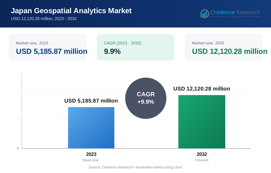
Japan Geospatial Analytics Market size was valued at USD 5,185.87 million in 2023 and is anticipated to reach USD 12,120.28 million by 2032, at a CAGR of 9.9% during the forecast period (2023-2032).
Several factors are propelling the growth of the geospatial analytics market in Japan. The increasing adoption of smart city initiatives necessitates advanced geospatial solutions for urban planning and infrastructure management. For instance, the Tokyo Smart City Studio, a collaboration between the Georgia Institute of Technology and the University of Tokyo, utilizes geospatial analytics for urban development. Additionally, the widespread use of location-based services in industries like retail, logistics, and transportation drives the demand for geospatial analytics. The integration of artificial intelligence and machine learning with geospatial data further enhances decision-making capabilities across various sectors. Moreover, Japan’s emphasis on disaster preparedness and environmental monitoring is prompting investment in real-time spatial data systems. The rise of digital twin technologies, which replicate physical environments virtually, is also gaining momentum across urban infrastructure projects.
Regionally, the Kanto region, encompassing Tokyo, leads in the adoption of geospatial analytics, driven by extensive smart city projects and technological infrastructure. The Kansai/Kinki region, including Osaka and Kyoto, follows closely, leveraging geospatial technologies in urban planning and disaster management. Other regions such as Chubu, Kyushu-Okinawa, Tohoku, Chugoku, Hokkaido, and Shikoku are also witnessing growth, supported by government initiatives and increasing awareness of the benefits of geospatial analytics. The concentration of industry players in metropolitan areas like Tokyo, Nagoya, and Osaka-Kobe-Kyoto further stimulates regional market development. Regional governments are also incorporating geospatial platforms in public transportation and emergency response systems. In addition, partnerships between universities and municipal bodies are accelerating innovation and workforce development in geospatial technologies.
Market Insights:
- Japan Geospatial Analytics Market size was valued at USD 5,185.87 million in 2023 and is anticipated to reach USD 12,120.28 million by 2032, at a CAGR of 9.9% during the forecast period (2023-2032).
- Government-led smart city initiatives, such as the Tokyo Smart City Studio, are driving the adoption of geospatial analytics for urban planning and infrastructure management.
- Geospatial analytics is increasingly utilized across various industries, including retail, logistics, transportation, agriculture, and construction, enhancing operational efficiency and decision-making.
- The integration of artificial intelligence (AI) and machine learning with geospatial data is enhancing predictive analytics and real-time monitoring capabilities across sectors.
- Japan's focus on disaster preparedness and environmental monitoring is prompting investments in real-time spatial data systems to improve emergency response and resilience.
- The rise of digital twin technologies, which create virtual replicas of physical environments, is gaining momentum in urban infrastructure projects, facilitating better planning and management.
- The Kanto region, encompassing Tokyo, leads in the adoption of geospatial analytics, followed by the Kansai/Kinki region, including Osaka and Kyoto. Other regions like Chubu, Kyushu-Okinawa, Tohoku, Chugoku, Hokkaido, and Shikoku are also witnessing growth, supported by government initiatives and increasing awareness of geospatial analytics benefits.
Report Scope
This report segments the Japan Geospatial Analytics Market as follow
[caption id="" align="aligncenter" width="766"]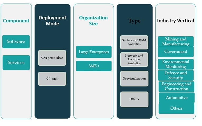 Japan Geospatial Analytics Market[/caption]
Government-Led Smart City Development
Government initiatives promoting smart city infrastructure play a pivotal role in driving the Japan Geospatial Analytics Market. Japan has been at the forefront of implementing smart urban planning strategies, particularly in major metropolitan areas such as Tokyo, Yokohama, and Osaka. The deployment of geospatial analytics is central to these initiatives, enabling authorities to manage resources efficiently, monitor traffic congestion, optimize utility networks, and enhance disaster preparedness. For instance, The Ministry of Land, Infrastructure, Transport and Tourism (MLIT) actively supports the use of spatial data to create sustainable, technologically advanced urban environments. This growing institutional backing is facilitating the widespread adoption of geospatial platforms in government planning and policy execution.
Rising Adoption Across Key Industry Verticals
The market is also gaining momentum due to the expanding application of geospatial analytics in diverse industries including transportation, logistics, agriculture, and construction. In logistics and supply chain management, geospatial solutions offer route optimization, asset tracking, and real-time delivery insights, helping businesses improve efficiency and reduce operational costs. Meanwhile, precision agriculture is leveraging spatial data to monitor soil conditions, crop health, and irrigation patterns, thus improving yield and sustainability. The construction sector uses GIS (Geographic Information Systems) for land assessment, site planning, and project lifecycle monitoring. As industries increasingly recognize the value of location-based intelligence, the demand for geospatial analytics solutions continues to grow across both public and private sectors.
Integration of Advanced Technologies
Another key driver fueling market growth is the integration of geospatial analytics with emerging technologies such as artificial intelligence (AI), machine learning (ML), and the Internet of Things (IoT). These advancements are enhancing the capabilities of geospatial systems, enabling predictive analytics, automated data processing, and real-time monitoring. For instance, AI algorithms can now analyze satellite imagery to detect land use changes or natural disasters more accurately and efficiently. Additionally, IoT-enabled sensors combined with GIS allow for dynamic monitoring of assets and environments, further extending the practical applications of geospatial tools. This technological convergence is accelerating innovation and providing more sophisticated, actionable insights for decision-makers across sectors.
Focus on Disaster Management and Environmental Monitoring
Japan’s susceptibility to natural disasters such as earthquakes, tsunamis, and typhoons underscores the importance of robust disaster management systems, where geospatial analytics plays a vital role. The government and disaster response agencies are employing real-time geospatial data to enhance early warning systems, optimize evacuation routes, and assess post-disaster impact for faster recovery. Furthermore, environmental monitoring is another critical area where spatial data supports sustainable land use, pollution tracking, and climate change mitigation. By leveraging high-resolution satellite imagery and spatial modeling, stakeholders can make informed decisions to safeguard both human populations and natural ecosystems. The emphasis on resilience and environmental stewardship continues to reinforce the demand for advanced geospatial solutions throughout the country.
Market Trends:
Growth of Cloud-Based Geospatial Platforms
One of the prominent trends shaping the Japan Geospatial Analytics Market is the rapid shift toward cloud-based platforms. As organizations across the public and private sectors generate increasing volumes of spatial data, the demand for scalable, flexible, and cost-efficient solutions is rising. Cloud-based geospatial platforms enable users to store, process, and analyze large datasets without the need for significant on-premise infrastructure. For instance, companies like Esri Japan and Oracle have expanded their cloud-based offerings to serve this growing need. These platforms also support real-time data sharing and collaboration, which is particularly valuable for distributed teams in disaster response, transportation management, and smart infrastructure projects.
Expansion of Location Intelligence in Retail and Urban Mobility
Another key trend is the growing use of location intelligence in retail and urban mobility. Japanese retailers are adopting geospatial analytics to map consumer behavior, optimize store placement, and tailor marketing campaigns based on foot traffic data. With the continued rise of e-commerce and omni-channel retailing, understanding customer location patterns has become a critical component of business strategy. Meanwhile, urban mobility planners are using spatial data to improve public transportation networks and reduce urban congestion. Geospatial insights are also enabling the design of bike lanes, pedestrian zones, and last-mile delivery systems, all of which contribute to more efficient and sustainable urban ecosystems.
Adoption of 3D Mapping and Digital Twin Technologies
Japan is also witnessing increasing adoption of 3D mapping and digital twin technologies, particularly in infrastructure development and smart city initiatives. These tools allow planners and engineers to create highly accurate digital replicas of physical environments, enabling better visualization and simulation. For instance, in cities like Tokyo and Fukuoka, 3D urban models are used to evaluate the impact of new buildings on wind flow, sunlight, and evacuation routes. Digital twins are also applied in utilities and construction projects to monitor asset conditions, predict failures, and optimize maintenance schedules. This trend is gaining momentum as municipalities and private firms invest in tools that enhance planning precision and reduce long-term costs.
Rising Collaboration Between Academia, Government, and Industry
Collaborative efforts between academic institutions, government agencies, and private industry are another defining trend in Japan’s geospatial analytics landscape. Universities such as the University of Tokyo and Kyoto University are partnering with municipalities to develop innovative geospatial solutions tailored to local needs. These collaborations often result in pilot projects that test applications in disaster prediction, resource allocation, or population management. Government-backed research funding is also fostering the development of specialized geospatial startups and open-source platforms. This ecosystem approach not only accelerates technological innovation but also promotes the broader adoption of geospatial analytics across sectors.
Market Challenges Analysis:
Data Privacy and Security Concerns
One of the significant restraints affecting the Japan Geospatial Analytics Market is the growing concern over data privacy and security. Geospatial analytics relies heavily on the collection and processing of location-based data, much of which can be sensitive or personally identifiable. In a country where data protection regulations are becoming increasingly stringent, organizations must navigate complex compliance requirements under the Act on the Protection of Personal Information (APPI). Companies handling geospatial data, particularly those offering cloud-based services, face challenges in ensuring data confidentiality, secure transmission, and storage. For example, a Japanese e-commerce company using a US-based cloud provider must secure specific customer consent and implement appropriate safeguards for cross-border data flows. These concerns can delay adoption, especially among public sector entities and smaller enterprises wary of potential data breaches and regulatory penalties.
Integration and Interoperability Limitations
Another major challenge is the lack of interoperability between different geospatial platforms and legacy systems. Many organizations in Japan continue to operate with siloed data infrastructures, making it difficult to integrate geospatial analytics into existing workflows. Variations in data formats, inconsistent standards, and outdated IT infrastructure hinder the seamless exchange of spatial information across departments and systems. Additionally, translating complex spatial outputs into actionable insights for non-technical users remains a persistent issue. This limitation not only affects operational efficiency but also restricts the broader application of geospatial tools in sectors like healthcare, utilities, and education. The challenge is especially pronounced in local government bodies, which may lack the technical expertise or funding to modernize their geospatial infrastructure.
Market Opportunities:
The Japan Geospatial Analytics Market presents strong opportunities driven by the country’s strategic focus on digital transformation and sustainable development. With the continued advancement of 5G infrastructure, there is an increasing potential for real-time geospatial data applications across urban planning, disaster management, and autonomous mobility. The integration of geospatial analytics with real-time sensor data, drones, and connected devices can significantly enhance decision-making for both government and private stakeholders. Moreover, Japan's ongoing investment in infrastructure renewal, particularly in aging transportation and utility systems, creates fertile ground for spatial analytics solutions that support predictive maintenance and long-term asset optimization. These initiatives are expected to stimulate demand for advanced GIS platforms and location intelligence services.
In addition, the rising interest in carbon neutrality and climate resilience offers emerging opportunities for geospatial applications in environmental monitoring and renewable energy planning. Spatial data is becoming essential for evaluating solar and wind farm placement, modeling environmental impact, and tracking deforestation or pollution trends. The government's push toward a greener economy, supported by smart energy grids and resource-efficient cities, will require precise geospatial inputs. Furthermore, Japan’s strong academic and research ecosystem, combined with active startup participation, can accelerate innovation in customized geospatial tools and analytics engines. As more sectors recognize the value of spatial intelligence, the market is likely to experience a surge in demand for scalable, AI-driven, and cloud-enabled geospatial solutions that address the country’s complex environmental and urban challenges.
Market Segmentation Analysis:
The Japan Geospatial Analytics Market is segmented across multiple dimensions, reflecting its wide-ranging applications and user base.
By component, the software segment dominates the market, driven by the increasing demand for spatial data modeling, real-time analytics, and advanced visualization tools. Services, including consulting, integration, and maintenance, are also gaining traction as organizations seek end-to-end support for deploying and optimizing geospatial systems.
By deployment mode, cloud-based solutions are experiencing faster growth due to their scalability, lower infrastructure costs, and ease of access for real-time collaboration. However, the on-premise segment maintains relevance in sectors such as defense and security, where data sovereignty and control are critical.
By organization size, large enterprises hold a significant share due to their greater investment capacity and broader application requirements. Meanwhile, small and medium-sized enterprises (SMEs) are increasingly adopting cloud-based and subscription-based geospatial solutions, supported by their growing digitalization efforts.
By type, network and location analytics lead the market, particularly in logistics, retail, and transportation. Surface and field analytics are extensively used in agriculture and environmental monitoring, while geovisualization tools are crucial for urban planning and infrastructure projects. The “others” segment includes emerging technologies like predictive mapping and AI-driven spatial modeling.
By industry verticals, government remains a major adopter, leveraging geospatial analytics for urban planning, disaster response, and public infrastructure. Environmental monitoring and defense also exhibit strong usage, while engineering, construction, automotive, and manufacturing industries are increasingly integrating spatial analytics to enhance operational efficiency and strategic planning.
Segmentation:
By Component:
- Software
- Services
By Deployment Mode:
- On-premise
- Cloud
By Organization size:
- Large Enterprises
- SME’s
By Type:
- Surface and Field Analytics
- Network and Location Analytics
- Geovisualization
- Others
By Industry Vertical:
- Mining and Manufacturing
- Government
- Environmental Monitoring
- Defence and Security
- Engineering and Construction
- Automotive
- Others
Regional Analysis:
The Japan Geospatial Analytics Market exhibits a regionally concentrated growth pattern, with the Kanto region holding the largest market share at 38%. This dominance is primarily due to Tokyo’s role as the economic and administrative center of the country. The region benefits from extensive smart city initiatives, robust infrastructure, and a high concentration of government agencies, research institutions, and private sector enterprises. Tokyo, Yokohama, and surrounding urban hubs are heavily investing in geospatial technologies to manage traffic systems, urban infrastructure, and emergency response mechanisms. Kanto's well-established digital ecosystem and policy-driven urban innovation continue to reinforce its leadership in the adoption of geospatial analytics.
The Kansai region, comprising cities such as Osaka, Kyoto, and Kobe, accounts for 23% of the market share. Kansai’s strong industrial base, combined with its growing smart city developments and university-driven research collaborations, is fueling demand for advanced geospatial solutions. Local governments in Osaka and Kyoto are increasingly using geospatial analytics for disaster risk reduction, infrastructure resilience, and environmental monitoring. The region’s cultural and historical importance also drives heritage site management through spatial technologies, further expanding the scope of application.
Chubu follows with a market share of 17%, driven by the region's manufacturing and logistics strength. With Nagoya as its industrial hub, Chubu utilizes geospatial tools for supply chain optimization, precision manufacturing, and infrastructure monitoring. Additionally, the area is investing in climate resilience, making environmental applications of geospatial analytics particularly relevant.
Other regions, including Kyushu-Okinawa, Tohoku, Chugoku, Hokkaido, and Shikoku, collectively account for 22% of the market. These areas are experiencing steady growth supported by regional development initiatives, especially in agriculture, environmental conservation, and rural infrastructure. The government’s “Digital Garden City” initiative, which aims to balance urban-rural development through digital technology, is encouraging geospatial adoption in less urbanized prefectures. Furthermore, regional universities and local startups are playing an active role in introducing customized geospatial applications tailored to local needs.
Key Player Analysis:
- Zenrin Co., Ltd.
- Hitachi, Ltd.
- Nippon Koei Co., Ltd.
- Toppan Inc.
- SAP SE
- Google, Inc.
- Bentley Systems, Incorporated
- Alteryx, Inc.
- Oracle Corporation
- Surveys and Mapping Japan
- Trimble, Inc.
- Esri
- Microsoft Corporation
- Space-Time Insight Japan
- Others
Competitive Analysis:
The Japan Geospatial Analytics Market is moderately competitive, with a mix of global technology providers and domestic players contributing to market dynamics. Key international firms such as Esri, Oracle Corporation, and Hexagon AB offer comprehensive GIS platforms and analytics tools, catering to government agencies and large enterprises. These companies maintain a strong presence through strategic partnerships and localized service offerings. Simultaneously, Japanese firms such as NEC Corporation, Hitachi, and NTT Data play a crucial role by integrating geospatial capabilities into broader digital infrastructure solutions. The market is also witnessing the rise of specialized startups focusing on AI-driven spatial analytics and custom applications for smart cities, disaster management, and logistics. Competition is driven by technological innovation, pricing strategies, and the ability to offer scalable, cloud-based solutions. Companies that provide integrated analytics with real-time visualization and decision-making tools are gaining a competitive edge as demand for advanced geospatial intelligence continues to grow.
Recent Developments:
- In November 2024, Google Cloud expanded its strategic partnership with NTT DATA to accelerate the adoption of cloud-based data analytics and generative AI solutions across Asia Pacific. This collaboration aims to empower enterprises in sectors such as healthcare, financial services, manufacturing, and the public sector with advanced AI and data analytics capabilities tailored to the region's unique needs. The partnership is expected to drive significant growth in NTT DATA’s cloud business in APAC, targeting a tenfold increase over three years.
- In February 2024, John Deere announced a strategic partnership with Hexagon’s Leica Geosystems to accelerate the digital transformation of the heavy construction industry. This collaboration aims to bring advanced geospatial technologies and solutions to construction professionals worldwide, enhancing efficiency and innovation in the sector.
- In January 2024, Maxar Technologies was awarded a contract by the National Geospatial-Intelligence Agency (NGA) to supply high-resolution satellite images and data for producing 3D maps and model data. This initiative focuses on the Indo-Pacific region, supporting U.S. military operations and strategic mapping needs across South Asia, Southeast Asia, Oceania, and the Pacific islands.
Market Concentration & Characteristics:
The Japan Geospatial Analytics Market exhibits a medium level of market concentration, characterized by a blend of global technology providers and domestic enterprises. Leading international firms such as Esri, Hexagon AB, and Trimble Inc. have established a significant presence, offering comprehensive GIS platforms and analytics tools tailored to various sectors. These companies leverage their extensive portfolios and technological innovations to maintain a competitive edge. Simultaneously, Japanese corporations like NEC Corporation, Hitachi, and NTT Data contribute substantially by integrating geospatial capabilities into broader digital infrastructure solutions. The market also witnesses participation from specialized startups focusing on AI-driven spatial analytics and custom applications for smart cities, disaster management, and logistics. This diverse competitive landscape fosters innovation and drives the adoption of advanced geospatial solutions across the country.
Report Coverage:
The research report offers an in-depth analysis based on Component, Deployment Mode, Organization size, Type and Industry Vertical. It details leading market players, providing an overview of their business, product offerings, investments, revenue streams, and key applications. Additionally, the report includes insights into the competitive environment, SWOT analysis, current market trends, as well as the primary drivers and constraints. Furthermore, it discusses various factors that have driven market expansion in recent years. The report also explores market dynamics, regulatory scenarios, and technological advancements that are shaping the industry. It assesses the impact of external factors and global economic changes on market growth. Lastly, it provides strategic recommendations for new entrants and established companies to navigate the complexities of the market.
Future Outlook:
- The Japan geospatial analytics market is projected to witness sustained double-digit growth, supported by increasing public and private sector investments.
- Government-backed smart city projects will drive broader adoption of spatial technologies in urban infrastructure management.
- Expansion of 5G and IoT networks will enhance real-time data processing capabilities for geospatial applications.
- Cloud-based platforms will dominate deployment preferences due to scalability and lower operational costs.
- AI and machine learning integration will enable predictive analytics and automation in spatial decision-making.
- Growing demand from the logistics and transportation sectors will boost the need for network and location analytics.
- Environmental monitoring and climate resilience initiatives will expand use cases in rural and coastal regions.
- Cross-sector collaboration among academia, government, and industry will accelerate innovation and skill development.
- Digital twin and 3D mapping technologies will become standard tools in construction and infrastructure planning.
- Regional markets outside Kanto will experience faster growth due to targeted digital inclusion efforts.
Request a Free Sample
Fill in your details and we'll send you a free sample report.
- Sample data tables & charts
- Research methodology
Need a Custom Version of This Report?
Tailor the scope, geography, or segments to your exact requirements.
- Custom geography or segment scope
- Direct access to our analyst team
Frequently Asked Questions
What is the current size of the Japan Geospatial Analytics Market?
What factors are driving the growth of the Japan Geospatial Analytics Market?
What are some challenges faced by the Japan Geospatial Analytics Market?
Who are the major players in the Japan Geospatial Analytics Market?
Table of Content
Chapter 1. Report Introduction
- 1.1 Report Description & Purpose
- 1.1.1 Report Title & Market Definition
- 1.1.2 Unique Selling Propositions (USP) & Key Differentiators
- 1.1.3 Value Proposition for Stakeholders
- 1.2 Research Objectives
- 1.2.1 Market Sizing Objectives (Volume & Revenue)
- 1.2.2 Segmentation Objectives
- 1.2.3 Competitive Intelligence Objectives
- 1.2.4 Forecast & Scenario Objectives
- 1.3 Report Scope
- 1.3.1 Japan Geospatial Analytics Scope – Types & Subtypes Covered
- 1.3.2 Geographic Scope – Regions & Countries Covered
- 1.3.3 Historical Period, Base Year & Forecast Period (2023; forecast to 2032)
- 1.3.4 Inclusions & Exclusions
- 1.4 HS Code & Classification Framework
- 1.5 Currency, Units & Pricing Basis
- 1.6 Target Stakeholders
- 1.7 Limitations & Assumptions
Chapter 2. Executive Summary
- 2.1 Global Japan Geospatial Analytics Market Snapshot
- 2.1.1 Market Size – Historical (2023) & Forecast (2023-2032) (2023: USD 5,185.87 million → 2032: USD 12,120.28 million)
- 2.1.2 Volume & Revenue – Global Totals
- 2.1.3 Key Market Highlights – Top Five Facts
- 2.2 Japan Geospatial Analytics Market Segmentation Snapshot
- 2.2.1 Market Split by Region – 2023 vs. 2032
- 2.3 Competitive Snapshot
- 2.3.1 Top 10 Players by Revenue Share – 2023
- 2.3.2 Top 10 Players by Volume Share – 2023
- 2.3.3 Recent Strategic Developments (18-Month Summary)
- 2.4 Key Investment Highlights & Strategic Conclusions
Chapter 3. Japan Geospatial Analytics Market Dynamics & Industry Analysis
- 3.1 Market Overview & Context
- 3.1.1 Japan Geospatial Analytics Market Position in the Broader Automotive Value Chain
- 3.1.2 OEM vs. Replacement Market Dynamics
- 3.1.3 Market Maturity & Development Stage by Region
- 3.2 Japan Geospatial Analytics Market Drivers
- 3.3 Japan Geospatial Analytics Market Restraints & Challenges
- 3.4 Japan Geospatial Analytics Market Opportunities
- 3.5 Porter's Five Forces Analysis
- 3.5.1 Threat of New Entrants
- 3.5.2 Bargaining Power of Suppliers
- 3.5.3 Bargaining Power of Buyers
- 3.5.4 Threat of Substitutes
- 3.5.5 Competitive Rivalry – Intensity Assessment
- 3.6 Japan Geospatial Analytics Value Chain Analysis
- 3.6.1 Upstream – Raw Material/Input Suppliers
- 3.6.1.1 Raw Material/Input 1
- 3.6.1.2 Raw Material/Input 2
- 3.6.1.3 Raw Material/Input 3
- 3.6.2 Midstream – Production/Manufacturing/Service Delivery
- 3.6.2.1 Production/Process Overview
- 3.6.2.2 Key Facility Locations & Capacity by Manufacturer
- 3.6.3 Downstream – Distribution & End Consumer
- 3.6.3.1 Primary Channel – B2B/OEM
- 3.6.3.2 Secondary Channels – Dealer, Retail, Online, Direct
- 3.6.4 Value Chain Profitability Analysis
- 3.6.1 Upstream – Raw Material/Input Suppliers
- 3.7 PESTEL Analysis
- 3.7.1 Political Factors
- 3.7.2 Economic Factors
- 3.7.3 Social Factors
- 3.7.4 Technological Factors
- 3.7.5 Environmental Factors
- 3.7.6 Legal Factors
- 3.8 Japan Geospatial Analytics Supply Chain Analysis
- 3.8.1 Raw Material/Input Supply Risk Assessment
- 3.8.2 Manufacturing Concentration Risk (Geographic Exposure)
- 3.8.3 Trade Disruption Impact Analysis
- 3.9 Regulatory & Policy Landscape
Note: The regulatory and policy landscape section covers regulations based on their applicability to the market, Japan Geospatial Analytics category, geography, and scope of the study. Only regulatory frameworks with a material impact on operations, compliance, trade, sustainability, or market access are analyzed in detail.
Chapter 4. Key Investment Pockets & Opportunity Analysis
- 4.1 Japan Geospatial Analytics Market Attractiveness Analysis
- 4.1.1 By Region – Investment Attractiveness Matrix (Volume × CAGR)
- 4.2 Absolute Revenue Growth Opportunity
- 4.2.1 By Region – Absolute USD Growth Through 2032
- 4.3 Incremental Volume Opportunity
- 4.3.1 By Region – Incremental Volume Through 2032
- 4.3.2 Segment – Incremental Volume
- 4.4 Emerging Submarket Opportunity Deep Dive (Subject to Applicability)
- 4.5 Emerging Market Opportunity Scorecards
- 4.5.1 United States
- 4.5.2 Europe
- 4.5.3 Asia
- 4.5.4 Middle East & Africa
Note: Emerging Market Opportunity Scorecards will be included based on relevance and strategic importance. Regions listed are indicative and may vary depending on data availability and market dynamics.
Chapter 5. Japan Geospatial Analytics Import-Export Analysis & Trade Flows
- 5.1 Global Trade Overview
- 5.1.1 Global Export Value by Country (2023)
- 5.1.2 Global Export Volume by Country (2023)
- 5.1.3 Global Import Value by Country (2023)
- 5.1.4 Global Import Volume by Country (2023)
- 5.1.5 Net Trade Balance by Country (2023)
- 5.2 Export Analysis – Segment
- 5.2.1 Type 1 (HS Code)
- 5.2.2 Type 2 (HS Code)
- 5.2.3 Type 3 (HS Code)
- 5.2.4 Type 4 (HS Code)
- 5.2.5 Type 5 (HS Code)
- 5.3 Import Analysis – Segment
- 5.3.1 Type 1 (HS Code)
- 5.3.2 Type 2 (HS Code)
- 5.3.3 Type 3 (HS Code)
- 5.3.4 Type 4 (HS Code)
- 5.3.5 Type 5 (HS Code)
- 5.4 Average Unit Trade Prices
- 5.4.1 Average Export Price – Segment & Country
- 5.4.2 Average Import Price – Segment & Source Country
- 5.4.3 Price Trends (2023)
- 5.5 Key Trade Route Analysis
- 5.5.1 Trade Route 1
- 5.5.2 Trade Route 2
- 5.5.3 Trade Route 3
- 5.5.4 Trade Route 4
- 5.5.5 Trade Route 5
- 5.6 Trade Policy Impact Assessment
- 5.6.1 US Anti-Dumping & Section 301 Tariffs
- 5.6.2 EU Customs Union Impact
- 5.6.3 Major Free Trade Agreements
- 5.6.4 USMCA Rules of Origin
Note: Trade policy analysis will be included only where relevant to the Japan Geospatial Analytics market.
Chapter 6. Competitive Landscape & Company Benchmarking
- 6.1 Japan Geospatial Analytics Market Concentration & Structure
- 6.1.1 Herfindahl-Hirschman Index (HHI) – vs. 2023
- 6.1.2 Tier 1, Tier 2 & Tier 3 Market Structure
- 6.1.3 Global, Regional & Local Player Dynamics
- 6.2 Japan Geospatial Analytics Market Share Analysis – 2023
- 6.2.1 Global Revenue Share by Company
- 6.2.2 Global Volume Share by Company
- 6.2.3 Regional Revenue Share
- 6.2.4 Market Share Evolution ( vs. 2023)
- 6.2.5 OEM Segment Share by Company
- 6.2.6 Replacement Segment Share by Company
- 6.3 Production/Delivery Capacity & Facility Analysis
- 6.3.1 Global Installed Capacity
- 6.3.2 Capacity Utilization Rates
- 6.3.3 Production/Output Volume
- 6.3.4 Facility Locations & Capacity Map
- 6.3.5 Planned Capacity Additions
- 6.4 Japan Geospatial Analytics Competitive Benchmarking Matrix
- 6.4.1 Revenue, Volume, CAGR & Profitability Comparison
- 6.4.2 Channel Revenue Mix
- 6.4.3 Geographic Revenue Exposure
- 6.4.4 R&D Intensity
- 6.4.5 Sustainability Maturity
- 6.5 Strategic Developments in Japan Geospatial Analytics (Last 24 Months)
- 6.5.1 Mergers, Acquisitions & Divestments
- 6.5.2 New Japan Geospatial Analytics Launches
- 6.5.3 Facility Expansions
- 6.5.4 Strategic Alliances, Joint Ventures & Partnerships
- 6.5.5 Distribution Expansion & Market Entry
- 6.5.6 Sustainability & ESG Initiatives
- 6.6 Competitive Strategy Mapping
- 6.6.1 Leader, Challenger, Follower & Niche Classification
- 6.6.2 Pricing Strategy Comparison
- 6.6.3 Channel Strategy Matrix
Note: Strategic developments are included based on their materiality and the availability of reliable information.
Chapter 7. Global Japan Geospatial Analytics Market – By Distribution Channel
- 7.1 Segment Overview
- 7.1.1 Volume & Revenue Split by Channel (2023 & 2032)
- 7.1.2 Channel Mix Evolution (2023-2032)
Chapter 8. Regional Market Analysis – Global Overview
- 8.1 Global Regional Overview
- 8.1.1 Regional Volume Share
- 8.1.2 Regional Revenue Share
- 8.1.3 Regional Volume by Region
- 8.1.4 Regional Revenue by Region
- 8.1.5 Regional Forecast Through 2032
- 8.2 Cross-Regional Segment Analysis
- 8.2.1 By Distribution Channel
- 8.2.2 By Brand/Price Tier
Chapter 9. North America Japan Geospatial Analytics Market
- 9.1 United States
- 9.2 Canada
- 9.3 Mexico
Chapter 10. Europe Japan Geospatial Analytics Market
- 10.1 Germany
- 10.2 France
- 10.3 Italy
- 10.4 United Kingdom
- 10.5 Spain
- 10.6 Poland
- 10.7 Russia
- 10.8 Netherlands
- 10.9 Belgium
- 10.10 Sweden
- 10.11 Denmark
- 10.12 Norway
- 10.13 Rest of Europe
Chapter 11. Asia Pacific Japan Geospatial Analytics Market
- 11.1 China
- 11.2 India
- 11.3 Japan
- 11.4 South Korea
- 11.5 Thailand
- 11.6 Indonesia
- 11.7 Vietnam
- 11.8 Malaysia
- 11.9 Australia
- 11.10 Rest of Asia Pacific
Chapter 12. Latin America Japan Geospatial Analytics Market
- 12.1 Brazil
- 12.2 Argentina
- 12.3 Colombia
- 12.4 Chile
- 12.5 Rest of Latin America
Chapter 13. Middle East Japan Geospatial Analytics Market
- 13.1 Saudi Arabia
- 13.2 United Arab Emirates
- 13.3 Turkey
- 13.4 Israel
- 13.5 Iran
- 13.6 Rest of the Middle East
Chapter 14. Africa Japan Geospatial Analytics Market
- 14.1 South Africa
- 14.2 Egypt
- 14.3 Nigeria
- 14.4 Morocco
- 14.5 Rest of Africa
Chapter 15. Japan Geospatial Analytics Company Profiles
- 15.1 [Company 01]
- 15.1.1 Company Overview
- 15.1.2 Key Management Personnel
- 15.1.3 Products & Services Portfolio
- 15.1.4 Financial Performance
- 15.1.5 Key Market Focus & Geographic Presence
- 15.1.6 Recent Developments & Strategic Initiatives
Note: The company profile list is preliminary and may change based on research findings, market developments, data availability, and client requirements.
Chapter 16. Appendices
- Appendix A – List of Abbreviations & Acronyms
- Appendix B – Industry Classification Code Reference – Full Series
- Appendix C – Production & Capacity Data Tables
- Appendix D – End-Use & Demand Base Tables
- Appendix E – Consumption & Replacement Rate Assumptions
- Appendix F – ASP Reference Tables
- Appendix G – Manufacturing & Facility Database
- Appendix H – Import-Export Data Tables
- Appendix I – Regulatory Summary Tables
- Appendix J – Primary Research Participant List (Anonymized)
- Appendix K – Primary Research Questionnaire Framework
- Appendix L – Data Sources & Bibliography
- Appendix M – Market Size Divergence & Source Comparison
Chapter 17. Research Methodology
- 17.1 Research Framework & Philosophy
- 17.2 Secondary Research – Sources, Hierarchy & Data Extraction
- 17.3 Data Modeling – Bottom-Up & Top-Down Market Sizing
- 17.4 Primary Research – Stakeholder Framework, LOI & Sample Sizes
- 17.5 Forecast Methodology – Regression, Scenario & Sensitivity Analysis
- 17.6 Quality Control – Four-Layer Validation Framework
- 17.7 Limitations & Standard Assumptions
- 17.8 Disclaimer