Home » Information and Communications Technology » Technology & Media » Brazil Geospatial Analytics Market

Brazil Geospatial Analytics Market

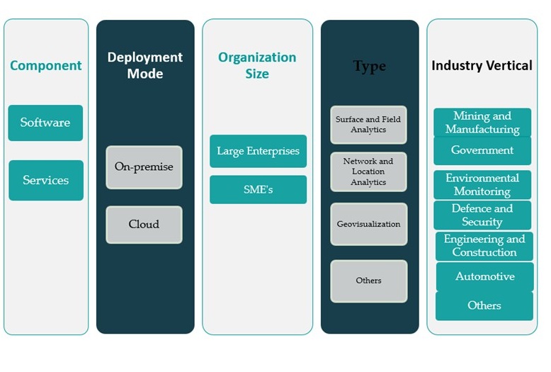
Brazil Geospatial Analytics Market By Component (Software, Services); By Deployment Mode (On-premise, Cloud); By Organization Size (Large Enterprises, SMEs); By Type (Surface and Field Analytics, Network and Location Analytics, Geovisualization, Others); By Industry Vertical (Mining and Manufacturing, Government, Environmental Monitoring, Defence and Security, Engineering and Construction, Automotive, Others) – Growth, Share, Opportunities & Competitive Analysis, 2024 – 2032

Price: $2699

Published: | Report ID: 94461 | Report Format : Excel, PDF
REPORT ATTRIBUTE DETAILS
Historical Period 2020-2023
Base Year 2024
Forecast Period 2025-2032
Brazil Geospatial Analytics Market Size 2023 USD 2,380.06 million
Brazil Geospatial Analytics Market, CAGR 9%
Brazil Geospatial Analytics Market Size 2032 USD 5,159.61 million

Market Overview:

Brazil Geospatial Analytics Market size was valued at USD 2,380.06 million in 2023 and is anticipated to reach USD 5,159.61 million by 2032, at a CAGR of 9% during the forecast period (2023-2032).

Several factors are propelling the growth of the geospatial analytics market in Brazil. Notably, the increasing demand for location-based services across industries is a significant driver. Technological advancements in spatial data processing have enhanced the capabilities of geospatial analytics, making them more accessible and efficient. Additionally, rising investments in smart cities and urban planning initiatives are contributing to market expansion. The increasing volume and variety of geospatial data, coupled with the integration of artificial intelligence (AI) and machine learning (ML), are enabling more sophisticated analyses and applications. These developments are particularly impactful in sectors such as agriculture, where precision farming techniques are being adopted, and in infrastructure development, where geospatial analytics aid in planning and resource management.

Regionally, the Southeast and South of Brazil are leading in the adoption of geospatial analytics, driven by higher urbanization rates and significant investments in infrastructure and technology. The Southeast region, encompassing major cities like São Paulo and Rio de Janeiro, serves as a hub for technological innovation and urban development projects. The South region, with states such as Paraná and Rio Grande do Sul, is also witnessing substantial growth due to advancements in agriculture and environmental monitoring. Other regions, including the Northeast, North, and Central-West, are gradually increasing their adoption of geospatial analytics, particularly in applications related to natural resource management and disaster response. The Brazilian government’s initiatives to promote digital transformation and smart city projects are expected to further enhance the regional growth of geospatial analytics across the country.

Design Element 2

Access crucial information at unmatched prices!

Request your sample report today & start making informed decisions powered by Credence Research!

Download Sample

CTA Design Element 3

Market Insights:

  • The Brazil Geospatial Analytics Market size was valued at USD 2,380.06 million in 2023 and is anticipated to reach USD 5,159.61 million by 2032, at a CAGR of 9% during the forecast period.
  • The increasing demand for location-based services (LBS) across industries like retail, logistics, and telecommunications is a major driver of market growth.
  • Technological advancements, particularly in artificial intelligence (AI) and machine learning (ML), are enhancing the accuracy and efficiency of geospatial analytics.
  • The Brazilian government’s focus on digital transformation and smart city initiatives is further accelerating the adoption of geospatial analytics solutions.
  • Precision agriculture is expanding in Brazil, with geospatial analytics playing a vital role in monitoring crop health, irrigation, and optimizing yields.
  • The Southeast and South regions lead in market adoption due to urbanization and higher investments in technology and infrastructure.
  • Despite the growth potential, high initial costs and a shortage of skilled professionals remain key challenges hindering widespread market penetration.

Report scope:

This report segments the Brazil Geospatial Analytics Market as follow

Brazil Geospatial Analytics Market

Market Drivers:

Growing Demand for Location-Based Services

The increasing reliance on location-based services (LBS) across diverse sectors is a primary driver of Brazil’s geospatial analytics market. Businesses in retail, transportation, logistics, and telecommunications are increasingly integrating geospatial technologies to optimize operations, improve service delivery, and enhance customer experience. For example, Zapt Tech specializes in Indoor Positioning Systems (IPS) and Real-time Locating Systems (RTLS), providing real-time location data that improves operational management and consumer experiences in environments like shopping malls and warehouses. In urban centers like São Paulo and Rio de Janeiro, LBS applications are being leveraged for fleet tracking, route optimization, and real-time navigation. The expansion of e-commerce and food delivery services has further fueled the demand for precise geospatial data, enabling companies to track shipments, predict delivery times, and streamline supply chains. This growing demand for real-time location intelligence significantly boosts the uptake of geospatial analytics solutions.

Technological Advancements and Integration with AI and ML

Rapid advancements in geospatial technologies and their integration with artificial intelligence (AI) and machine learning (ML) are transforming data processing capabilities in Brazil. Modern geospatial analytics tools can now handle large volumes of spatial data with improved speed and accuracy. By incorporating AI and ML, organizations can gain deeper insights through pattern recognition, predictive analytics, and anomaly detection. These capabilities are particularly beneficial in agriculture for precision farming, in environmental science for climate monitoring, and in urban development for infrastructure planning. The technological evolution of cloud computing and big data analytics also contributes to making geospatial platforms more scalable and accessible, thus driving their adoption across both public and private sectors.

Supportive Government Policies and Smart City Initiatives

The Brazilian government’s active promotion of digital transformation and smart city initiatives plays a critical role in driving the geospatial analytics market. National programs focusing on infrastructure development, sustainable urbanization, and public service improvement rely heavily on spatial data analysis. For example, the Environmental Monitoring of Brazilian Biomes project, supported by the Fundo Amazônia, has established deforestation monitoring systems for biomes such as the Mata Atlântica, Caatinga, Pampa, and Pantanal, providing critical spatial data for environmental management and policy-making. Several municipalities are adopting Geographic Information Systems (GIS) to manage transportation networks, utilities, and urban planning efforts. Furthermore, public-private partnerships are facilitating the deployment of geospatial infrastructure, particularly in disaster risk management and environmental protection. These initiatives are not only enhancing operational efficiency in government agencies but are also encouraging private enterprises to invest in geospatial technologies.

Expansion in Agriculture and Environmental Monitoring

Brazil’s vast agricultural landscape and ecological diversity create a strong need for advanced monitoring and analysis tools. Geospatial analytics is increasingly used in precision agriculture to monitor crop health, manage irrigation, and optimize yields. In regions like the Cerrado and Amazon, environmental agencies are employing spatial technologies to track deforestation, illegal mining, and biodiversity loss. The growing focus on sustainability and climate resilience further drives the use of remote sensing and GIS tools. As agribusiness and environmental conservation efforts expand, geospatial analytics will remain a vital component in achieving data-driven decision-making and long-term ecological balance.

Market Trends:

Integration of Artificial Intelligence and Machine Learning

The Brazil geospatial analytics market is witnessing a significant shift with the integration of artificial intelligence (AI) and machine learning (ML) technologies. These advancements enable more sophisticated analysis of spatial data, allowing for predictive modeling and the identification of complex patterns. For example, REVO Geoscience leverages machine learning to enhance the evaluation of geospatial databases, particularly for mineral exploration, supporting informed decision-making in sectors reliant on geosciences. The incorporation of AI and ML enhances the capabilities of geospatial analytics tools, making them more efficient and effective in processing large volumes of data. This trend is particularly beneficial in sectors such as agriculture, where precision farming techniques are being adopted, and in infrastructure development, where geospatial analytics aid in planning and resource management.

Expansion of Cloud-Based Geospatial Solutions

There is a growing trend towards the adoption of cloud-based geospatial analytics solutions in Brazil. Cloud computing offers scalability, flexibility, and cost-effectiveness, making geospatial analytics more accessible to a broader range of users. The shift to cloud platforms facilitates real-time data processing and sharing, which is crucial for applications such as disaster management, urban planning, and environmental monitoring. This transition is supported by the increasing availability of high-speed internet and advancements in cloud infrastructure within the country.

Emphasis on Environmental Monitoring and Sustainability

Environmental monitoring has become a focal point in Brazil’s geospatial analytics market. The country’s rich biodiversity and extensive rainforests necessitate robust monitoring systems to track deforestation, illegal logging, and biodiversity changes. For instance, Lactec, a leading Brazilian innovation company, partnered with EOMAP to use satellite data analytics and remote sensing for environmental impact assessments, such as tracking the spread of tailing mud from the 2015 Mariana dam disaster along the Doce River basin. Geospatial analytics play a critical role in these efforts by providing accurate and timely data, enabling authorities to make informed decisions. This emphasis aligns with global initiatives for environmental preservation and climate change mitigation, further amplifying the demand for geospatial solutions.

Development of Smart Cities and Urban Planning

The Brazilian government’s initiatives to develop smart cities are driving the adoption of geospatial analytics in urban planning. Geospatial data is instrumental in optimizing infrastructure development, addressing traffic congestion, and enhancing public services. Cities like São Paulo and Rio de Janeiro are leveraging geospatial analytics to improve transportation networks, manage utilities, and plan for sustainable urban growth. These developments not only improve the quality of life for residents but also attract investments, further stimulating the market for geospatial analytics.

Market Challenges Analysis:

High Initial Costs and Limited Budget Allocation

One of the primary restraints affecting the growth of the Brazil geospatial analytics market is the high initial cost associated with implementing advanced geospatial solutions. The procurement of high-resolution satellite imagery, sophisticated Geographic Information System (GIS) software, LiDAR equipment, and robust data processing infrastructure demands significant investment. Small and medium-sized enterprises (SMEs) and regional municipalities often lack the financial resources to adopt these technologies at scale. Additionally, many public sector agencies in Brazil operate with constrained budgets, which limits their ability to invest in modernizing their spatial data systems. This cost barrier significantly impedes broader market penetration, especially outside major metropolitan areas.

Shortage of Skilled Workforce and Technical Expertise

Another pressing challenge is the limited availability of professionals skilled in geospatial analytics, remote sensing, and spatial data science. Despite growing awareness of the technology’s potential, Brazil faces a skills gap that hinders effective deployment and utilization of geospatial tools. For instance, a Geospatial World Annual Readership Survey found that around 84% of 2,000 surveyed industry professionals acknowledged there was a significant skill gap between industry requirements and the available workforce. Many organizations struggle to interpret complex spatial data or integrate it effectively into decision-making processes due to a lack of trained personnel. Moreover, the need for continuous training and upskilling in evolving technologies—such as artificial intelligence integration with GIS platforms—further adds to operational complexity. The lack of institutional emphasis on geospatial education and limited academic programs focused on spatial technologies exacerbate the talent shortage, creating long-term constraints on market development.

Market Opportunities:

The Brazil geospatial analytics market presents significant opportunities driven by the nation’s growing emphasis on digital transformation and smart infrastructure development. With rapid urbanization and increasing demand for efficient resource management, there is a rising need for spatial data to support city planning, transportation optimization, and public safety initiatives. The government’s smart city initiatives, particularly in major urban centers like São Paulo, Curitiba, and Brasília, create substantial prospects for geospatial solution providers. As these projects scale, the demand for advanced analytics tools that can process real-time data, monitor environmental impact, and enhance public services is expected to surge, fostering market expansion.

Beyond urban planning, Brazil’s expansive agricultural landscape and ecological zones offer opportunities for geospatial analytics in environmental monitoring and precision farming. The agribusiness sector increasingly adopts remote sensing and GIS technologies to boost crop productivity, manage water resources, and monitor land use. Additionally, international interest in Amazon rainforest conservation and deforestation control programs opens the door for partnerships with environmental organizations and government agencies seeking sophisticated spatial analysis tools. These developments position Brazil as a promising market for global and domestic players aiming to capitalize on sustainability-driven applications of geospatial analytics across public, private, and non-governmental sectors.

Market Segmentation Analysis:

The Brazil geospatial analytics market is segmented across multiple dimensions, each contributing uniquely to the market’s growth.

By component, the software segment leads in revenue share due to increasing adoption of Geographic Information Systems (GIS), remote sensing tools, and analytical platforms. The services segment is also gaining momentum as businesses seek consultation, integration, and training support to deploy and maintain geospatial solutions effectively.

By deployment mode, cloud-based solutions are increasingly favored for their scalability, flexibility, and lower upfront costs. Many enterprises in Brazil are transitioning to cloud platforms to enable real-time data analysis and remote access. However, on-premise deployment remains relevant among organizations with strict data security requirements, especially within defense and government sectors.

By organization size, large enterprises dominate market adoption due to their capacity to invest in advanced spatial tools and integrate them into enterprise resource planning (ERP) systems. However, the adoption among small and medium enterprises (SMEs) is expanding, particularly in agriculture, retail, and logistics, as affordable cloud-based solutions become more accessible.

By type, network and location analytics hold a prominent share, driven by demand for traffic monitoring, route optimization, and logistics planning. Geovisualization and surface and field analytics are increasingly adopted in environmental and engineering applications for terrain modeling and asset monitoring.

By industry verticals, the government sector leads in adoption for urban planning, census mapping, and infrastructure development. Environmental monitoring and defense also represent key growth areas, while sectors like automotive, mining, and construction are leveraging geospatial insights for operational efficiency and strategic planning.

Shape Your Report to Specific Countries or Regions & Enjoy 30% Off!

Segmentation:

By Component:

  • Software
  • Services

By Deployment Mode:

  • On-premise
  • Cloud

By Organization size:

  • Large Enterprises
  • SME’s

By Type:

  • Surface and Field Analytics
  • Network and Location Analytics
  • Geovisualization
  • Others

By Industry Vertical:

  • Mining and Manufacturing
  • Government
  • Environmental Monitoring
  • Defence and Security
  • Engineering and Construction
  • Automotive
  • Others

Regional Analysis:

The Brazil geospatial analytics market exhibits distinct regional dynamics, influenced by varying levels of economic development, technological infrastructure, and sector-specific demands across the country’s five major regions: Southeast, South, Northeast, North, and Central-West.

Southeast Region

The Southeast region stands as the dominant force in Brazil’s geospatial analytics market, accounting for approximately 45% of the national market share. This prominence is attributed to the region’s high population density, advanced technological infrastructure, and concentration of major urban centers such as São Paulo and Rio de Janeiro. The region’s robust economy and significant investments in infrastructure and smart city initiatives drive the demand for geospatial analytics in urban planning, transportation, and public safety applications.

South Region

The South region holds a substantial share of the market, estimated at around 25%. States like Paraná, Santa Catarina, and Rio Grande do Sul are leveraging geospatial analytics to enhance agricultural productivity, environmental monitoring, and disaster management. The region’s strong emphasis on agribusiness and sustainable development fuels the adoption of geospatial technologies for precision farming and natural resource management.

Northeast Region

The Northeast region accounts for approximately 15% of the market share. Despite facing challenges such as limited technological infrastructure and economic disparities, the region is gradually embracing geospatial analytics, particularly in tourism development, urban planning, and environmental conservation. Initiatives aimed at promoting regional development and addressing climate-related issues are expected to bolster the adoption of geospatial technologies in this area.

North Region

The North region, encompassing the vast Amazon rainforest, represents about 10% of the market. The region’s focus on environmental preservation, biodiversity monitoring, and combating illegal activities like deforestation and mining drives the demand for geospatial analytics. Government agencies and environmental organizations utilize geospatial tools for surveillance, land use planning, and sustainable resource management in this ecologically sensitive area.

Central-West Region

The Central-West region holds the remaining 5% of the market share. Known for its extensive agricultural activities, particularly in states like Mato Grosso and Goiás, the region employs geospatial analytics for crop monitoring, soil analysis, and irrigation management. The integration of geospatial technologies in agribusiness operations enhances efficiency and supports sustainable farming practices.

Key Player Analysis:

  • GeoAmbiente
  • SISGeo
  • Brasgeo
  • Terralog
  • SAP SE
  • Google, Inc.
  • Bentley Systems, Incorporated
  • Alteryx, Inc.
  • Oracle Corporation
  • Trimble, Inc.
  • Esri
  • Microsoft Corporation
  • Mapbiomas
  • Geolink
  • Others

Competitive Analysis:

The Brazil geospatial analytics market features a competitive landscape marked by the presence of both global and regional players striving to expand their footprint. Leading international companies such as Esri, Hexagon AB, and Trimble Inc. dominate the market through advanced GIS platforms, remote sensing capabilities, and comprehensive location-based analytics solutions. These firms maintain strong partnerships with government agencies and private enterprises, offering customized tools tailored to local demands. Regional players and startups are also emerging, focusing on niche applications in environmental monitoring, agriculture, and smart city planning. Competitive strategies include technological innovation, cloud-based service offerings, and integration of AI and machine learning into geospatial systems. As demand for real-time spatial insights rises, market participants are intensifying efforts in R&D, localization, and strategic alliances to strengthen their market presence and meet the evolving needs of Brazil’s dynamic sectors.

Recent Developments:

  • In August 2024, L3Harris Technologies launched its Geospatial Analytics Platform, specifically designed to support defense and intelligence operations. This new product aims to enhance the capabilities of organizations in analyzing and interpreting geospatial data, providing advanced tools for critical decision-making in security and defense contexts.
  • In late 2024, Google announced a significant update to its geospatial analytics offerings with the release of Google Earth Engine version 1.4.2rc0. This update is part of Google’s ongoing efforts to enhance geospatial data processing and analysis capabilities for users in North America and globally, enabling more advanced environmental monitoring and urban planning application.
  • In October 2024, Bentley Systems, Incorporated announced a strategic partnership with Google to integrate Google’s high-quality geospatial content with Bentley’s infrastructure engineering software and digital twin platform. This collaboration allows Bentley clients and developers to leverage Google Maps Platform geospatial content, such as photorealistic 3D tiles, within their digital workflows.

Market Concentration & Characteristics:

The Brazil geospatial analytics market demonstrates moderate to high market concentration, with a few dominant international players such as Esri, Hexagon AB, and Trimble Inc. holding a significant share due to their advanced technological capabilities and long-standing presence in the region. These companies offer comprehensive geospatial platforms that are widely adopted by government institutions, infrastructure developers, and environmental agencies. However, the market is also characterized by the emergence of regional firms and startups catering to localized demands, particularly in agriculture, urban planning, and disaster management. The market exhibits characteristics of technological intensity, with strong emphasis on innovation, integration of artificial intelligence, and shift toward cloud-based deployments. Customization, data accuracy, and interoperability across platforms remain critical competitive factors. Additionally, increasing public-private collaborations and digital transformation initiatives are shaping the market dynamics, fostering a more diverse and innovation-driven competitive environment.

Report Coverage:

The research report offers an in-depth analysis based on Component, Deployment Mode, Organization size, Type and Industry Vertical. It details leading market players, providing an overview of their business, product offerings, investments, revenue streams, and key applications. Additionally, the report includes insights into the competitive environment, SWOT analysis, current market trends, as well as the primary drivers and constraints. Furthermore, it discusses various factors that have driven market expansion in recent years. The report also explores market dynamics, regulatory scenarios, and technological advancements that are shaping the industry. It assesses the impact of external factors and global economic changes on market growth. Lastly, it provides strategic recommendations for new entrants and established companies to navigate the complexities of the market.

Future Outlook:

  • Brazil’s geospatial analytics market is projected to witness robust growth driven by expanding smart city initiatives and digital infrastructure investments.
  • Cloud-based deployment models will gain further traction due to their scalability and cost-efficiency across various industries.
  • The integration of AI and machine learning will enhance predictive analytics and real-time geospatial decision-making.
  • Increased adoption of precision agriculture tools will fuel demand for spatial analysis in Brazil’s agribusiness sector.
  • Environmental monitoring applications will expand, especially in regions facing deforestation and climate-related challenges.
  • Government-backed initiatives for infrastructure modernization will create new opportunities for geospatial data providers.
  • The proliferation of mobile GIS applications will empower field-based operations in logistics, construction, and utilities.
  • Education and training programs in spatial analytics will strengthen the local talent pool and reduce the skills gap.
  • Public-private partnerships will play a key role in accelerating geospatial solution deployment across sectors.
  • Advancements in 3D mapping and drone-based data collection will open new frontiers for urban and resource planning.

CHAPTER NO. 1 : INTRODUCTION 18

1.1.1. Report Description 19

Purpose of the Report 19

USP & Key Component 19

1.1.2. Key Benefits for Stakeholders 19

1.1.3. Target Audience 20

1.1.4. Report Scope 20

CHAPTER NO. 2 : EXECUTIVE SUMMARY 21

2.1. Geospatial Analytics Market Snapshot 21

2.1.1. Brazil Geospatial Analytics Market, 2018 – 2032 (USD Million) 22

CHAPTER NO. 3 : GEOPOLITICAL CRISIS IMPACT ANALYSIS 23

3.1. Russia-Ukraine and Israel-Palestine War Impacts 23

CHAPTER NO. 4 : GEOSPATIAL ANALYTICS MARKET – INDUSTRY ANALYSIS 24

4.1. Introduction 24

4.2. Market Drivers 25

4.2.1. Driving Factor 1 Analysis 25

4.2.2. Driving Factor 2 Analysis 26

4.3. Market Restraints 27

4.3.1. Restraining Factor Analysis 27

4.4. Market Opportunities 28

4.4.1. Market Opportunities Analysis 28

4.5. Porter’s Five Force analysis 29

4.6. Value Chain Analysis 30

4.7. Buying Criteria 31

CHAPTER NO. 5 : ANALYSIS COMPETITIVE LANDSCAPE 32

5.1. Company Market Share Analysis – 2023 32

5.1.1. Brazil Geospatial Analytics Market: Company Market Share, by Revenue, 2023 32

5.1.2. Brazil Geospatial Analytics Market: Top 6 Company Market Share, by Revenue, 2023 32

5.1.3. Brazil Geospatial Analytics Market: Top 3 Company Market Share, by Revenue, 2023 33

5.2. Brazil Geospatial Analytics Market Company Revenue Market Share, 2023 34

5.3. Company Assessment Metrics, 2023 35

5.3.1. Stars 35

5.3.2. Emerging Leaders 35

5.3.3. Pervasive Players 35

5.3.4. Participants 35

5.4. Start-ups /Code Assessment Metrics, 2023 35

5.4.1. Progressive Companies 35

5.4.2. Responsive Companies 35

5.4.3. Dynamic Companies 35

5.4.4. Starting Blocks 35

5.5. Strategic Developments 36

5.5.1. Acquisition & Mergers 36

New Product Launch 36

Regional Expansion 36

5.6. Key Players Product Matrix 37

CHAPTER NO. 6 : PESTEL & ADJACENT MARKET ANALYSIS 38

6.1. PESTEL 38

6.1.1. Political Factors 38

6.1.2. Economic Factors 38

6.1.3. Social Factors 38

6.1.4. Technological Factors 38

6.1.5. Environmental Factors 38

6.1.6. Legal Factors 38

6.2. Adjacent Market Analysis 38

CHAPTER NO. 7 : GEOSPATIAL ANALYTICS MARKET – BY COMPONENT SEGMENT ANALYSIS 39

7.1. Geospatial Analytics Market Overview, by Component Segment 39

7.1.1. Geospatial Analytics Market Revenue Share, By Component, 2023 & 2032 40

7.1.2. Geospatial Analytics Market Attractiveness Analysis, By Component 41

7.1.3. Incremental Revenue Growth Opportunities, by Component, 2024 – 2032 41

7.1.4. Geospatial Analytics Market Revenue, By Component, 2018, 2023, 2027 & 2032 42

7.2. Software 43

7.3. Services 44

CHAPTER NO. 8 : GEOSPATIAL ANALYTICS MARKET – BY DEPLOYMENT MODE SEGMENT ANALYSIS 45

8.1. Geospatial Analytics Market Overview, by Deployment Mode Segment 45

8.1.1. Geospatial Analytics Market Revenue Share, By Deployment Mode, 2023 & 2032 46

8.1.2. Geospatial Analytics Market Attractiveness Analysis, By Deployment Mode 47

8.1.3. Incremental Revenue Growth Opportunities, by Deployment Mode, 2024 – 2032 47

8.1.4. Geospatial Analytics Market Revenue, By Deployment Mode, 2018, 2023, 2027 & 2032 48

8.2. On-premise 49

8.3. Cloud 50

CHAPTER NO. 9 : GEOSPATIAL ANALYTICS MARKET – BY TYPE SEGMENT ANALYSIS 51

9.1. Geospatial Analytics Market Overview, by Type Segment 51

9.1.1. Geospatial Analytics Market Revenue Share, By Type, 2023 & 2032 52

9.1.2. Geospatial Analytics Market Attractiveness Analysis, By Type 53

9.1.3. Incremental Revenue Growth Opportunities, by Type, 2024 – 2032 53

9.1.4. Geospatial Analytics Market Revenue, By Type, 2018, 2023, 2027 & 2032 54

9.2. Surface and Field Analytics 55

9.3. Network and Location Analytics 56

9.4. Geovisualization 57

9.5. Others 58

CHAPTER NO. 10 : GEOSPATIAL ANALYTICS MARKET – BY INDUSTRY VERTICAL SEGMENT ANALYSIS 59

10.1. Geospatial Analytics Market Overview, by Industry Vertical Segment 59

10.1.1. Geospatial Analytics Market Revenue Share, By Industry Vertical, 2023 & 2032 60

10.1.2. Geospatial Analytics Market Attractiveness Analysis, By Industry Vertical 61

10.1.3. Incremental Revenue Growth Opportunities, by Industry Vertical, 2024 – 2032 61

10.1.4. Geospatial Analytics Market Revenue, By Industry Vertical, 2018, 2023, 2027 & 2032 62

10.2. Mining and Manufacturing 63

10.3. Government 64

10.4. Environmental Monitoring 65

10.5. Defence and Security 66

10.6. Engineering and Construction 67

10.7. Automotive 68

10.8. Others 69

CHAPTER NO. 11 : GEOSPATIAL ANALYTICS MARKET – BRAZIL 70

11.1. Brazil 70

11.1.1. Key Highlights 70

11.2. Component 71

11.3. Brazil Geospatial Analytics Market Revenue, By Component, 2018 – 2023 (USD Million) 71

11.4. Brazil Geospatial Analytics Market Revenue, By Component, 2024 – 2032 (USD Million) 71

11.5. Deployment Mode 72

11.6. Brazil Geospatial Analytics Market Revenue, By Deployment Mode, 2018 – 2023 (USD Million) 72

11.6.1. Brazil Geospatial Analytics Market Revenue, By Deployment Mode, 2024 – 2032 (USD Million) 72

11.7. Enterprise Size 73

11.8. Brazil Geospatial Analytics Market Revenue, By Enterprise Size, 2018 – 2023 (USD Million) 73

11.8.1. Brazil Geospatial Analytics Market Revenue, By Enterprise Size, 2024 – 2032 (USD Million) 73

11.9. Type 74

11.10. Brazil Geospatial Analytics Market Revenue, By Type, 2018 – 2023 (USD Million) 74

11.10.1. Brazil Geospatial Analytics Market Revenue, By Type, 2024 – 2032 (USD Million) 74

11.11. Industry Vertical 75

11.11.1. Brazil Geospatial Analytics Market Revenue, By Industry Vertical, 2018 – 2023 (USD Million) 75

11.11.2. Brazil Geospatial Analytics Market Revenue, By Industry Vertical, 2024 – 2032 (USD Million) 75

CHAPTER NO. 12 : COMPANY PROFILES 76

12.1. GeoAmbiente 76

12.1.1. Company Overview 76

12.1.2. Product Portfolio 76

12.1.3. Swot Analysis 76

12.1.4. Business Strategy 77

12.1.5. Financial Overview 77

12.2. SISGeo 78

12.3. Brasgeo 78

12.4. Terralog 78

12.5. SAP SE 78

12.6. Google, Inc. 78

12.7. Bentley Systems, Incorporated 78

12.8. Alteryx, Inc. 78

12.9. Oracle Corporation 78

12.10. Trimble, Inc. 78

12.11. Esri 78

12.12. Microsoft Corporation 78

12.13. Mapbiomas 78

12.14. Geolink 78

12.15. Others 78

About Us 79

]

List of Figures

FIG NO. 1. Brazil Geospatial Analytics Market Revenue, 2018 – 2032 (USD Million) 22

FIG NO. 2. Porter’s Five Forces Analysis for Brazil Geospatial Analytics Market 29

FIG NO. 3. Value Chain Analysis for Brazil Geospatial Analytics Market 30

FIG NO. 4. Company Share Analysis, 2023 32

FIG NO. 5. Company Share Analysis, 2023 32

FIG NO. 6. Company Share Analysis, 2023 33

FIG NO. 7. Geospatial Analytics Market – Company Revenue Market Share, 2023 34

FIG NO. 8. Geospatial Analytics Market Revenue Share, By Component, 2023 & 2032 40

FIG NO. 9. Market Attractiveness Analysis, By Component 41

FIG NO. 10. Incremental Revenue Growth Opportunities by Component, 2024 – 2032 41

FIG NO. 11. Geospatial Analytics Market Revenue, By Component, 2018, 2023, 2027 & 2032 42

FIG NO. 12. Brazil Geospatial Analytics Market for Software, Revenue (USD Million) 2018 – 2032 43

FIG NO. 13. Brazil Geospatial Analytics Market for Services, Revenue (USD Million) 2018 – 2032 44

FIG NO. 14. Geospatial Analytics Market Revenue Share, By Deployment Mode, 2023 & 2032 46

FIG NO. 15. Market Attractiveness Analysis, By Deployment Mode 47

FIG NO. 16. Incremental Revenue Growth Opportunities by Deployment Mode, 2024 – 2032 47

FIG NO. 17. Geospatial Analytics Market Revenue, By Deployment Mode, 2018, 2023, 2027 & 2032 48

FIG NO. 18. Brazil Geospatial Analytics Market for On-premise, Revenue (USD Million) 2018 – 2032 49

FIG NO. 19. Brazil Geospatial Analytics Market for Cloud, Revenue (USD Million) 2018 – 2032 50

FIG NO. 20. Geospatial Analytics Market Revenue Share, By Type, 2023 & 2032 52

FIG NO. 21. Market Attractiveness Analysis, By Type 53

FIG NO. 22. Incremental Revenue Growth Opportunities by Type, 2024 – 2032 53

FIG NO. 23. Geospatial Analytics Market Revenue, By Type, 2018, 2023, 2027 & 2032 54

FIG NO. 24. Brazil Geospatial Analytics Market for Surface and Field Analytics, Revenue (USD Million) 2018 – 2032 55

FIG NO. 25. Brazil Geospatial Analytics Market for Network and Location Analytics, Revenue (USD Million) 2018 – 2032 56

FIG NO. 26. Brazil Geospatial Analytics Market for Geovisualization, Revenue (USD Million) 2018 – 2032 57

FIG NO. 27. Brazil Geospatial Analytics Market for Others, Revenue (USD Million) 2018 – 2032 58

FIG NO. 28. Geospatial Analytics Market Revenue Share, By Industry Vertical, 2023 & 2032 60

FIG NO. 29. Market Attractiveness Analysis, By Industry Vertical 61

FIG NO. 30. Incremental Revenue Growth Opportunities by Industry Vertical, 2024 – 2032 61

FIG NO. 31. Geospatial Analytics Market Revenue, By Industry Vertical, 2018, 2023, 2027 & 2032 62

FIG NO. 32. Brazil Geospatial Analytics Market for Mining and Manufacturing, Revenue (USD Million) 2018 – 2032 63

FIG NO. 33. Brazil Geospatial Analytics Market for Government, Revenue (USD Million) 2018 – 2032 64

FIG NO. 34. Brazil Geospatial Analytics Market for Environmental Monitoring, Revenue (USD Million) 2018 – 2032 65

FIG NO. 35. Brazil Geospatial Analytics Market for Defence and Security, Revenue (USD Million) 2018 – 2032 66

FIG NO. 36. Brazil Geospatial Analytics Market for Engineering and Construction, Revenue (USD Million) 2018 – 2032 67

FIG NO. 37. Brazil Geospatial Analytics Market for Automotive, Revenue (USD Million) 2018 – 2032 68

FIG NO. 38. Brazil Geospatial Analytics Market for Others, Revenue (USD Million) 2018 – 2032 69

FIG NO. 39. Brazil Geospatial Analytics Market Revenue, 2018 – 2032 (USD Million) 70


List of Tables

TABLE NO. 1. : Brazil Geospatial Analytics Market: Snapshot 21

TABLE NO. 2. : Drivers for the Geospatial Analytics Market: Impact Analysis 25

TABLE NO. 3. : Restraints for the Geospatial Analytics Market: Impact Analysis 27

TABLE NO. 4. : Brazil Geospatial Analytics Market Revenue, By Component, 2018 – 2023 (USD Million) 71

TABLE NO. 5. : Brazil Geospatial Analytics Market Revenue, By Component, 2024 – 2032 (USD Million) 71

TABLE NO. 6. : Brazil Geospatial Analytics Market Revenue, By Deployment Mode, 2018 – 2023 (USD Million) 72

TABLE NO. 7. : Brazil Geospatial Analytics Market Revenue, By Deployment Mode, 2024 – 2032 (USD Million) 72

TABLE NO. 8. : Brazil Geospatial Analytics Market Revenue, By Enterprise Size, 2018 – 2023 (USD Million) 73

TABLE NO. 9. : Brazil Geospatial Analytics Market Revenue, By Enterprise Size, 2024 – 2032 (USD Million) 73

TABLE NO. 10. : Brazil Geospatial Analytics Market Revenue, By Type, 2018 – 2023 (USD Million) 74

TABLE NO. 11. : Brazil Geospatial Analytics Market Revenue, By Type, 2024 – 2032 (USD Million) 74

TABLE NO. 12. : Brazil Geospatial Analytics Market Revenue, By Industry Vertical, 2018 – 2023 (USD Million) 75

TABLE NO. 13. : Brazil Geospatial Analytics Market Revenue, By Industry Vertical, 2024 – 2032 (USD Million) 75

Frequently Asked Questions

What is the current size of the Brazil Geospatial Analytics Market?

The Brazil Geospatial Analytics Market size was valued at USD 2,380.06 million in 2023 and is anticipated to reach USD 5,159.61 million by 2032, at a CAGR of 9% during the forecast period.

What factors are driving the growth of the Brazil Geospatial Analytics Market?

Growth is driven by rising demand for location-based services, smart city investments, and the integration of AI and machine learning into spatial data analytics.

What are some challenges faced by the Brazil Geospatial Analytics Market?

High implementation costs and a shortage of skilled professionals are major challenges limiting widespread adoption.

Who are the major players in the Brazil Geospatial Analytics Market?

Key players include Esri, Hexagon AB, Trimble Inc., and emerging regional firms focused on agriculture, environmental monitoring, and urban planning.

Brazil Naphtha Market

Published:
Report ID: 3438

Brazil Cardiovascular Devices Market

Published:
Report ID: 93004

Brazil Industrial Solvents Market

Published:
Report ID: 91108

Brazil Single-Use Bio-Processing Systems Market

Published:
Report ID: 90939

Brazil Soy-Based Chemicals Market

Published:
Report ID: 90382

Brazil Industrial Fasteners Market

Published:
Report ID: 83484

Brazil Feminine Hygiene Products Market

Published:
Report ID: 89568

Brazil Water Pump Market

Published:
Report ID: 89073

Brazil Off-the-Road Tire Market

Published:
Report ID: 88735

3D Bioprinters Market

Published:
Report ID: 963

Smart Climate Control Market

Published:
Report ID: 102340

Data Center Substation Market

Published:
Report ID: 102175

3Pl Software Market

Published:
Report ID: 102097

Industrial Wireless Vibration Sensors Network Market

Published:
Report ID: 7901

NVDIMM Market

Published:
Report ID: 14253

Passenger Service System (PSS) Market

Published:
Report ID: 8813

Network Emulators Market

Published:
Report ID: 101870

Biometric Recognition Market

Published:
Report ID: 101778

Cross-Border Payments Market

Published:
Report ID: 101803

Loudspeaker Market

Published:
Report ID: 12186

Satellite Communication Terminal Market

Published:
Report ID: 101610

Purchase Options

The report comes as a view-only PDF document, optimized for individual clients. This version is recommended for personal digital use and does not allow printing.
$2699

To meet the needs of modern corporate teams, our report comes in two formats: a printable PDF and a data-rich Excel sheet. This package is optimized for internal analysis and multi-location access, making it an excellent choice for organizations with distributed workforce.
$3699

The report will be delivered in printable PDF format along with the report’s data Excel sheet. This license offers 100 Free Analyst hours where the client can utilize Credence Research Inc.’s research team. It is highly recommended for organizations seeking to execute short, customized research projects related to the scope of the purchased report.
$8699

Credence Staff 3

WILLIAM, North America

Support Staff at Credence Research

KEITH PHILLIPS, Europe

Lee - CR Sales Staff

LEE VALLANCE, Asia Pacific

Smallform of Sample request

Report delivery within 24 to 48 hours

– Other Info –

What people say?-

User Review

I am very impressed with the information in this report. The author clearly did their research when they came up with this product and it has already given me a lot of ideas.

Jana Schmidt
CEDAR CX Technologies

– Connect with us –

Phone

+91 6232 49 3207


support

24/7 Research Support


sales@credenceresearch.com

– Research Methodology –

Going beyond the basics: advanced techniques in research methodology

– Trusted By –

Pepshi, LG, Nestle
Motorola, Honeywell, Johnson and johnson
LG Chem, SIEMENS, Pfizer
Unilever, Samsonite, QIAGEN

Request Sample